


Everest Three Passes Trek Distance 2026: Daily KM & Pass-by-Pass Breakdown

Updated [July 14th, 2026]. Written and reviewed by Suman Shrestha, licensed guide (Nepal Government License No. 2212)
The Everest Three Passes Trek covers approximately 160 km (100 miles) in an anti-clockwise loop through the Khumbu region. That number sounds manageable until you factor in the hidden reality: over 11,000 meters of cumulative ascent and descent, three high passes above 5,300 meters, which is collectively known as the three high pass trek, renowned for its difficulty due to both the total distance and the significant altitude gain required. The terrain ranges from glacial moraine to loose scree and icy boulder fields. Distance alone tells you almost nothing about what this trek actually demands.
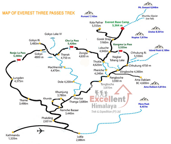 This article breaks down the itinerary specifically: Namche – Tengboche – Dingboche – Chhukung – Kongma La – Lobuche – Everest Base Camp – Cho La – Gokyo – Renjo La – Thame – Namche – Lukla. Every distance figure here comes from practical field data—GPS tracks from our Sherpa leaders and years of guiding groups across these passes at Excellent Himalaya Trek and Expedition Pvt. Ltd.
As the trekking guide, I have personally led expeditions over Kongma La in whiteout conditions and watched trekkers underestimate Cho La because the map showed “only 9 kilometers.” This article exists to prevent that mistake. The total distance matters far less than understanding how that distance breaks down day by day, pass by pass, and the altitude gain involved at each stage.
Quick Answer
- Total distance: approximately 160–170 km (100–106 miles) round trip from Lukla, anti-clockwise or clockwise loop
- Duration: 18–20 trekking days, plus 1–2 buffer days for Lukla flight delays
- Highest sleeping altitude: Gorak Shep, 5,164 m
- Highest walking points: Kala Patthar (5,545 m) and Kongma La Pass (5,535 m)
- Total elevation gain and loss combined: 11,000–12,000+ m
- Three passes: Kongma La (5,535 m), Cho La (5,420 m), Renjo La (5,360 m)
- Permits required: Sagarmatha National Park Entry Permit and Khumbu Pasang Lhamu Rural Municipality Permit. No TIMS card is required in the Khumbu region as of 2026.
The Everest Three Passes Trek covers approximately 160 to 170 km (100 to 106 miles) in a loop through the Khumbu region, crossing three passes above 5,300 m: Kongma La, Cho La, and Renjo La. That range sounds manageable until you factor in the hidden reality: over 11,000 m of cumulative ascent and descent on terrain that shifts from glacial moraine to loose scree to icy boulder fields. Distance alone tells you almost nothing about what this trek actually demands.
This article breaks down the itinerary specifically: Namche – Tengboche – Dingboche – Chhukung – Kongma La – Lobuche – Everest Base Camp – Cho La – Gokyo – Renjo La – Thame – Namche – Lukla. Every distance figure here comes from practical field data, GPS tracks from our Sherpa guides, and years of leading groups across these passes at Excellent Himalaya Trek and Expedition Pvt. Ltd. (Reg. No. 175840/074/075, Tourism License No. 2432).
As lead guide, I have personally led expeditions over Kongma La in whiteout conditions and watched trekkers underestimate Cho La because the map showed “only 9 kilometers.” This article exists to prevent that mistake. Total distance matters far less than understanding how it breaks down day by day, pass by pass, and altitude band by altitude band.
The Big Picture: Total Distance, Elevation & Time at a Glance
Before the daily breakdown, here is the dashboard view of the entire loop. These numbers represent what you will actually walk, not theoretical map lines.
| Metric | Value |
| Total trekking distance | Approximately 160–170 km / 100–106 miles for the full loop from Lukla |
| Typical trip length | 18–20 trekking days, plus 1–2 buffer days in Kathmandu or Namche for flight delays |
| Highest sleeping point | Gorak Shep, 5,164 m |
| Highest walking points | Kala Patthar, 5,545 m; Kongma La Pass, 5,535 m |
| Total cumulative altitude gain | 5,500–6,000 m net gain |
| Total up and down combined | 11,000–12,000+ m |
| Hardest single days | 5–12 km requiring 7–9 hours due to altitude, scree, and glacier crossings |
Each of the three passes, Kongma La, Cho La, and Renjo La, involves 1,400 to 1,800 m of combined elevation gain and loss in a single day. At 5,000+ m, where oxygen availability drops to roughly half of sea level, even “flat” sections feel like sustained uphill effort.
Excellent Himalaya uses GPS-tracked logs from our Sherpa guides to refine these figures each season. Trail conditions shift with snowfall, glacier movement, and erosion, so the numbers here reflect current field reality rather than outdated guidebook estimates.

Anti-Clockwise Itinerary: Daily Distance, Gain/Loss & Terrain
The anti-clockwise direction, Kongma La first, then Cho La, then Renjo La, is our preferred routing at Excellent Himalaya. This sequence allows better acclimatization by placing the slightly lower Renjo La last, when trekkers are most fatigued but also best adapted to altitude. It also provides more gradual exposure to technical terrain, reducing acute mountain sickness (AMS) risk.
Below is the complete 18–20 day program starting from Tribhuvan International Airport in Kathmandu.
| Day | Route | Distance (km) | Elevation Gain/Loss | Terrain Type |
| 1 | Arrival Kathmandu (1,400 m) | 0 | — | Briefing, gear check |
| 2 | Flight to Lukla (2,840 m); trek to Phakding (2,610 m) | 8 | -250 m net | Stone trail along Dudh Koshi River |
| 3 | Phakding – Namche Bazaar (3,440 m) | 10–11 | +830 m | Suspension bridges, steep zigzags |
| 4 | Namche acclimatization day | 3–6 | +440 m / -440 m | Side hike to Everest View Hotel (3,880 m) |
| 5 | Namche – Tengboche (3,860 m) | 9–10 | +600 m / -200 m | Pine and rhododendron forest, monastery ridge |
| 6 | Tengboche – Dingboche (4,410 m) | 10–11 | +650 m | Pangboche valley, mixed pasture and rock |
| 7 | Dingboche acclimatization day | 4–7 | +600 m / -600 m | Hike toward Nangkartshang Peak (~5,000 m) |
| 8 | Dingboche – Chhukung (4,730 m) | 6 | +320 m | High valley trail, Island Peak views |
| 9 | Chhukung – Kongma La (5,535 m) – Lobuche (4,940 m) | 11–12 | +800 m / -900 m | Steep scree, boulder fields, Khumbu Glacier moraine |
| 10 | Lobuche – Gorak Shep (5,164 m) – Everest Base Camp (5,364 m) – Gorak Shep | 11–13 | +450 m / -250 m | Glacial moraine, uneven rock and sand |
| 11 | Gorak Shep – Kala Patthar (5,545 m) – Dzongla (4,830 m) | 10–12 | +500 m / -850 m | Rocky trail, pre-dawn ascent |
| 12 | Dzongla – Cho La Pass (5,420 m) – Thagnak (4,700 m) | 9–10 | +600 m / -700 m | Rocky ramp, crevassed glacier, icy descent |
| 13 | Thagnak – Gokyo (4,790 m) | 7–8 | +150 m | Moraine along Ngozumpa Glacier |
| 14 | Gokyo Ri (5,357 m) ascent and Gokyo Lakes exploration | 4–6 | +600 m / -600 m | Steep but non-technical climb |
| 15 | Gokyo – Renjo La (5,360 m) – Lungden (4,380 m) | 11–12 | +700 m / -1,100 m | Stone steps, switchbacks, scree |
| 16 | Lungden – Thame (3,800 m) | 9–10 | -600 m | Old trade route, gradual descent |
| 17 | Thame – Namche Bazaar (3,440 m) | 8–9 | -350 m | Forest traverse, mani walls |
| 18 | Namche – Lukla (2,840 m) | 18–20 | -1,000 m / +400 m | Long descent with multiple short climbs |
| 19 | Morning flight Lukla – Kathmandu | 0 | — | Final departure and debrief |
Day 3 brings trekkers to Namche Bazaar, the first major acclimatization milestone before continuing deeper into the Khumbu. The “160–170 km loop” hides real day-to-day variability: some days cover as little as 4–6 km with minimal elevation change, others stretch to 18–20 km with relentless undulation. The distance column tells you how far; the terrain column tells you how hard.
Clockwise Route: Daily Distance, Gain/Loss & Terrain
Some trekkers opt for the clockwise direction, which reverses the pass order: Renjo La first, then Cho La, then Kongma La. This route follows Lukla to Namche, then Thame and Lungden before crossing Renjo La to Gokyo, then Cho La to Dzongla, and finally Kongma La to Lobuche and Everest Base Camp. Below is the typical 18–20 day clockwise itinerary.
| Day | Route | Distance (km) | Elevation Gain/Loss | Terrain Type |
| 1 | Arrival Kathmandu (1,400 m) | 0 | — | Briefing, gear check |
| 2 | Flight to Lukla (2,840 m); trek to Phakding (2,610 m) | 8 | -250 m net | Stone trail along Dudh Koshi River |
| 3 | Phakding – Namche Bazaar (3,440 m) | 10–11 | +830 m | Suspension bridges, steep zigzags |
| 4 | Namche acclimatization day | 3–6 | +440 m / -440 m | Side hike to Everest View Hotel (3,880 m) |
| 5 | Namche – Thame (3,800 m) | 17–18 | +400 m / -40 m | Forest trail, mani walls |
| 6 | Thame – Lungden (4,380 m) | 10 | +600 m | Old trade route, gradual ascent |
| 7 | Lungden – Renjo La Pass (5,360 m) – Gokyo (4,790 m) | 11–12 | +700 m / -1,100 m | Stone steps, switchbacks, scree |
| 8 | Gokyo Ri ascent and exploration day | 4–6 | +600 m / -600 m | Steep but non-technical climb |
| 9 | Gokyo – Thagnak (4,700 m) via Cho La Pass (5,420 m) | 9–10 | +600 m / -700 m | Rocky ramp, glacier crossing, icy descent |
| 10 | Thagnak – Dzongla (4,830 m) | 7–8 | +150 m | Moraine along Ngozumpa Glacier |
| 11 | Dzongla – Kala Patthar (5,545 m) – Gorak Shep (5,164 m) | 10–12 | +500 m / -850 m | Rocky trail, pre-dawn ascent |
| 12 | Gorak Shep – Everest Base Camp (5,364 m) – Lobuche (4,940 m) | 11–13 | +450 m / -250 m | Glacial moraine, uneven rock and sand |
| 13 | Lobuche – Kongma La Pass (5,535 m) – Chhukung (4,730 m) | 11–12 | +800 m / -900 m | Steep scree, boulder fields, glacier moraine |
| 14 | Chhukung – Dingboche (4,410 m) | 6 | -320 m | High valley trail |
| 15 | Dingboche acclimatization day | 4–7 | +600 m / -600 m | Hike toward Nangkartshang Peak (~5,000 m) |
| 16 | Dingboche – Tengboche (3,860 m) | 10–11 | -650 m | Pangboche valley, mixed pasture and rock |
| 17 | Tengboche – Namche Bazaar (3,440 m) | 9–10 | -600 m / +200 m | Pine and rhododendron forest, monastery ridge |
| 18 | Namche – Lukla (2,840 m) | 18–20 | -1,000 m / +400 m | Long descent with multiple short climbs |
| 19 | Morning flight Lukla – Kathmandu | 0 | — | Final departure and debrief |
Anti-Clockwise vs Clockwise: Local Guide Insights from Excellent Himalaya
From years of leading groups, Excellent Himalaya guides favor the anti-clockwise itinerary for its acclimatization profile and psychological pacing. Starting with Kongma La, the longest and most physically demanding pass, while trekkers are fresh builds confidence early and allows gradual adaptation to altitude. The final pass, Renjo La, is technically easier and comes when trekkers are better acclimatized, reducing risk.
The clockwise route begins with Renjo La, a steep, long ascent early in the trek when trekkers are less acclimatized, which can increase the risk of altitude sickness and fatigue. Cho La, the most technical pass with glacier crossings, comes in the middle, while Kongma La, the most physically taxing pass, arrives at the end when cumulative fatigue is highest.
Both routes cover a similar total distance and elevation profile, but our field experience shows the anti-clockwise direction offers a safer, more manageable progression for most trekkers, especially those new to high passes. Our guides adapt pace and rest points to client fitness, but the anti-clockwise route consistently produces higher completion and satisfaction rates.

Distance From Key Points: Segment-by-Segment Reference (NEW)
Beyond the day-by-day tables above, these are the point-to-point segment distances trekkers most often search for when planning pace, water resupply, and rest stops.
| Segment | Distance (km) | Typical Time |
| Lukla to Phakding | 8 km | 3–4 hours |
| Phakding to Namche Bazaar | 10–11 km | 5–6 hours |
| Namche to Everest Base Camp (via classic route) | ~48 km | 4–5 trekking days |
| Chhukung to Kongma La to Lobuche | 11–12 km | 7–9 hours |
| Lobuche to Gorak Shep | 4–5 km | 2–3 hours |
| Gorak Shep to Everest Base Camp | 3–4 km one way | 2–3 hours one way |
| Gorak Shep to Kala Patthar | 1.5–2 km one way | 1.5–2 hours (pre-dawn) |
| Dzongla to Cho La Pass to Thagnak | 9–10 km | 6–7 hours |
| Gokyo to Renjo La to Lungden | 11–12 km | 6–7 hours |
| Namche to Lukla (final descent day) | 18–20 km | 7–8 hours |
Ranges reflect variation from group pace, weather, and route condition rather than measurement error. GPS distance and “trail-feel” distance diverge most sharply on the three pass days, where a slow party can average 1 km per hour or less through technical sections.
Phase 1 — The Approach: Building Distance and Acclimatization
The approach phase spans Lukla to Chhukung, approximately 8 trekking days where you gain altitude gradually and build walking rhythm before the high passes. This is where the whole trek succeeds or fails.
Daily distances average 8–11 km between Lukla, Phakding, Namche, Tengboche, and Dingboche. Net elevation gain is intentionally limited to 500–800 m per day to prevent altitude sickness. Two acclimatization hikes are scheduled at Namche (3,440 m) and Dingboche (4,410 m), each involving 3–7 km side trips to higher points.
The trek starts on stone-paved village paths through rhododendron forest, crossing suspension bridges over the Dudh Koshi River. Past 3,500 m, the terrain opens into yak pastures, sandy valley floors, and rocky moraine. Pace naturally slows from 3–4 km/hour at lower elevations to 2–2.5 km/hour above Tengboche.
Guide Insight: This phase is where we start monitoring clients closely, hydration, sleep quality, appetite, and oxygen saturation readings. We track conditions, not just kilometers. Anyone struggling with 10–12 km days at this stage needs an honest evaluation before attempting all three high passes.
The gradual ascent strategy matters because AMS affects roughly 20–50% of trekkers above 4,000 m. Our acclimatization protocol is built to reduce this risk substantially compared to rushing the approach.
Phase 2 — The Three High Passes: Kongma La, Cho La, Renjo La
This is the core of the high pass trek: three passes, three different types of “distance,” all between roughly 5,300 and 5,550 m elevation. Here, 5–12 km can equate to 7–9 hours of effort, and combined ascent and descent on a pass day often reaches 1,400–1,800 m.
What makes this trek unlike any other in the Everest region is not the horizontal distance; it is the relentless vertical oscillation combined with technical terrain at extreme altitude. This is where an experienced local guide becomes non-negotiable: route-finding across scree fields, glacier sections, and poorly marked passes cannot be safely improvised by beginner trekkers or those navigating solely by trek map.
Kongma La: The Longest and Wildest Day
On the anti-clockwise route, you cross Kongma La Pass (5,535 m) first, the transit from Chhukung to Lobuche. This is often the psychologically hardest day because trekkers have not yet proven to themselves that they can handle passes at this altitude.
Total trail distance: 11–12 km. Elevation gain: +800–900 m from Chhukung to the pass. Elevation loss: -800–900 m descending to Lobuche across glacial moraine.
The day begins with a long, gradual approach to the valley from Chhukung. After 3–4 km, the trail steepens into loose scree and rock slabs requiring careful foot placement. The final approach to the pass often features snow patches, and in late winter or early spring, occasional cornice lines require navigation adjustments.
The descent is where many groups slow significantly. There is no clear trail, only boulder fields and Khumbu Glacier moraine that demand constant attention. One misstep on tired legs can mean a twisted ankle or worse.
Guide Insight: Strong trekkers in stable weather typically complete Kongma La in 7–9 hours. Slower parties may need 10 hours or more. We enforce pre-dawn starts from Chhukung with headlamps, clearing the pass before afternoon cloud or wind is essential.
Specific risks: navigation challenges if fresh snow obscures cairn markers, no teahouses between Chhukung and Lobuche, so water planning must be precise, and higher dehydration risk from extended exposure and cold, dry air. I have turned groups back within 45 minutes of the pass when the wind built faster than forecast. The summit view means nothing if you cannot descend safely.
Cho La: Shorter Distance, Higher Technical Demand
Cho La Pass (5,420 m) between Dzongla and Thagnak covers only 9–10 km, shorter than Kongma La on paper. But this is what our team calls “the technical distance,” and many trekkers remember it as the most intimidating crossing of the three.
Day statistics: total distance approximately 9–10 km; ascent +600–650 m from Dzongla to the pass; descent -700–800 m to Thagnak, often on a steep trail.
Terrain: the early section is a steep, rocky ramp with occasional frozen stream crossings. The central section has hard-packed snow or ice on the pass plateau, including walking directly on a small crevassed glacier in some seasons. The west side descent has loose rock, scree, and sometimes verglas (thin ice) on shaded slabs.
Guide Insight: Excellent Himalaya guides require microspikes or light crampons on Cho La in most conditions. Distance becomes almost meaningless here; a slow party may average 1 km per hour or less through the upper glacier section. We probe the snow surface and choose safer lines when conditions are uncertain.
Specific hazards: rockfall zones in late morning when the sun hits frozen slopes (early crossings are mandatory), hidden ice under fresh snow requiring careful testing, and narrow traverses with exposure on both sides. Contrast this with Kongma La: a slightly shorter distance, but many trekkers report Cho La as scarier because of direct glacier exposure and the feeling of commitment once you are on the ice.
Renjo La: The Scenic Finale With a Long Descent
Renjo La Pass (5,360 m) is the final pass when walking anti-clockwise, connecting Gokyo to Lungden and then Thame. Technically easier than Cho La, but by this point your body has accumulated two weeks of high altitude effort.
Key statistics: Gokyo to Renjo La to Lungden distance approximately 11–12 km; ascent from Gokyo +700 m to the pass; descent on the western side -1,100 m or more to Lungden.
Terrain: the east side has well-defined stone steps rising above the Gokyo Lakes, then rocky zigzags with short snow patches. The pass crest is a wide vantage point, often windy but less exposed to ice than Cho La. The west side has a long series of stone staircases, broken rock, and scree descending into the Bhote Koshi valley.
Guide Insight: Despite being technically easier, accumulated fatigue makes the final 3–4 km to Lungden feel endless. Knee strain on the steep ascents and descents catches many trekkers off guard. We enforce more frequent micro-breaks and adjust pace aggressively on this day.
The reward: from Renjo La, you see one of the finest panoramas in the Himalayas, Mount Everest, Lhotse, Makalu, and the full chain of surrounding peaks aligned above all five Gokyo Lakes. This view alone justifies the extended journey.
Phase 3 — The Descent: Longer Kilometers, Faster Hours
After Renjo La, distances per day grow, 10 to 20 km, but hiking feels notably easier. Thicker air below 4,000 m, gentler trail, and established trekking route surfaces let you cover ground faster than at any point since leaving Namche.
Typical descent segments: Lungden to Thame, 9–10 km, mostly downhill on an established trade route near the old Nangpa La caravan path. Thame to Namche, 8–9 km, contouring and descending through forest and traditional Sherpa hamlets. Namche to Lukla, 18–20 km, the longest day of the whole trek with many short ascents and descents as the trail crosses village spurs.
Many trekkers underestimate this final stretch. Although technically simpler than the passes, cumulative fatigue amplifies every meter. Sore joints from two weeks of rocky trail can turn the last 18–20 km into a mental challenge as much as a physical one.
Guide Insight: We start early from Namche on the Lukla push, schedule fixed snack breaks, set hydration targets, and monitor blister management closely. The descent is not the time to rush, but it is also not the place to linger if the weather threatens to delay flights.
Phase 3 — The Descent: Longer Kilometers, Faster Hours
After Renjo La, distances per day grow, 10 to 20 km, but hiking feels notably easier. Thicker air below 4,000 m, gentler trail, and established trekking route surfaces let you cover ground faster than at any point since leaving Namche.
Typical descent segments: Lungden to Thame, 9–10 km, mostly downhill on an established trade route near the old Nangpa La caravan path. Thame to Namche, 8–9 km, contouring and descending through forest and traditional Sherpa hamlets. Namche to Lukla, 18–20 km, the longest day of the whole trek, with many short ascents and descents as the trail crosses village spurs.
Many trekkers underestimate this final stretch. Although technically simpler than the passes, cumulative fatigue amplifies every meter. Sore joints from two weeks of rocky trail can turn the last 18–20 km into a mental challenge as much as a physical one.
Guide Insight: We start early from Namche on the Lukla push, schedule fixed snack breaks, set hydration targets, and monitor blister management closely. The descent is not the time to rush, but it is also not the place to linger if the weather threatens to delay flights.

Distance vs. Reality: Why “Flat KM” Doesn’t Exist in the Khumbu
The 160–170 km Three Passes distance cannot be compared to the same distance of city walking or a lowland trail. Three factors make every kilometer in Sagarmatha National Park fundamentally different.
The vertical component
Net daily elevation gains appear modest, 500 to 900 m typically. But the constant up-and-down nature of the Himalayan trail often doubles the on-paper effort. The cumulative 11,000+ m of total ascent and descent means you effectively climb and descend more than Everest’s height during the trek.
Altitude effects
At 4,500–5,500 m, reduced oxygen slashes VO2 max by 30–50%. Heart rate and breathing remain elevated even on “flat” glacial moraine. Each kilometer requires measurably more energy than the identical distance at sea level, and trekkers commonly burn 1.5 to 2 times more calories per kilometer at these elevations.
Surface type
Loose scree, broken moraine, ice, and snow significantly slow the pace compared with the dirt path. What takes 15 minutes on a groomed trail at home can take 45 minutes on Khumbu moraine.
Guide Rules of Thumb for Pacing
- At 3,000 m on a good trail, 3–4 km/hour is realistic
- At 5,000 m on moraine or snow: 1–2 km/hour is already very good
- On pass days with mixed terrain: expect 1–1.5 km/hour average
Psychological distance matters too. From Gokyo, Renjo La looks close, perhaps 2 km away. In reality, zigzag ascents and altitude slow you to 2–3 hours for that visible distance. Snow-capped peaks and extreme cold create visual deception that frustrates trekkers who fixate on what they can see rather than what the terrain demands. Excellent Himalaya focuses on time windows, weather patterns, and client conditions rather than raw kilometers when making daily safety decisions.
Permits & Logistics: How Excellent Himalaya Manages a 160+ km High-Altitude Loop
Organizing 160 to 170 km of high-altitude trekking through three passes above 5,300 m is a logistics project: permits, Lukla flight management, porter loads, emergency protocols, and flexible accommodation arrangements.
| Permit | Purpose | Typical Cost (foreign trekkers) | Where Issued |
| Sagarmatha National Park Entry Permit | Entry into the UNESCO-listed national park covering the entire Khumbu region | Approx. NPR 3,000–3,400 | Nepal Tourism Board, Kathmandu, or Monjo checkpoint |
| Khumbu Pasang Lhamu Rural Municipality Permit | Local government entry fee funding trail maintenance, rescue coordination, and community projects | Approx. NPR 2,000–3,000 | Lukla or Monjo checkpoint |
Route planning
Daily walking times are calculated based on season, group size, and fitness, not just distance. GPS waypoints for all three passes, alternative trails, and safe turn-back points are pre-programmed.
Guiding team
Group leaders are government-licensed, Khumbu-native guides trained in wilderness first aid and high-altitude risk management. Pulse oximeters and symptom checklists are used every evening above Namche. Guides are trained to recognize early signs of HAPE and HACE.
Porter and baggage strategy
Standard allowance is up to 9–10 kg per client in a sleeping bag and gear duffel. Porter ratios maintain loads within 20–22 kg per porter over passes, which keeps pace consistent and safety margins wider on steep, icy terrain.
Weather and contingency planning
1–2 buffer days are built into every itinerary for Lukla flight delays, which run at a roughly 50% delay rate in peak season. Weather holds at Dingboche, Chhukung, or Gokyo before pass days allow flexibility when conditions deteriorate.
Communication and rescue
Local networks and radio coverage points are mapped for the entire route. Helicopter evacuation is pre-arranged for AMS emergencies or injury, with satellite communication backup for sections beyond cell coverage.
Solo trekkers may cover a similar total distance, but a local team dramatically increases the margin for error in complex terrain. The trek cost includes logistics that cannot be replicated by showing up with a trek map and hoping for good weather.
Who Is the Everest Three Passes Distance Really For?
This is not a first-trek-in-your-life route. The Three Passes Trek suits strong EBC Trek alumni and experienced hikers seeking a harder objective than the standard Everest Base Camp Trek.
Fitness Expectations
- Ability to walk 6–8 hours daily with a daypack on rough ground
- Capacity for occasional 9–10 hour days on pass crossings
- Comfortable doing 1,000 m+ of mixed ascent/descent in a single day at low altitude before the trip
Experience Profile
- Previous high-altitude experience above 4,000 m strongly recommended
- At a minimum, a solid multi-day trekking or backpacking background
- Comfort using trekking poles and moving on rocky, uneven surfaces
- Crampon or microspike familiarity is a significant bonus for Cho La
Mindset Requirements
- Realistic attitude about turning back or modifying plans for safety
- Distance targets never override health or weather concerns
- Understanding that this challenging trek requires flexibility
Comparison with EBC Trek: the classic Everest Base Camp Trek covers approximately 130 km with around 7,000 m total elevation change over 12–14 days. The Three Passes Trek adds 30–40 km and 4,000+ m of additional vertical through technical terrain. Views of Pokalde Peak, the Gokyo Lakes, and the Ngozumpa Glacier are rewards exclusive to those who complete the full loop.
Join Excellent Himalaya on the Everest Three Passes: Next Steps
If you are ready to tackle the full 160 km anti-clockwise loop—the hardest trek in the Everest region—we invite you to plan your expedition with Excellent Himalaya Trek and Expedition Pvt. Ltd.
Custom distance and pace options:
- Flexibility to add acclimatization days at Namche, Dingboche, Chhukung, or Gokyo
- Options to shorten or lengthen the loop based on fitness and available time
- Add-ons available: Gokyo Ri sunrise, Chhukung Ri, or extended lakeside exploration
Are you Ready to start planning?
Contact Excellent Himalaya via www.excellenttrek.com, email: [email protected], or WhatsApp: +9779851203181 for a custom Three Passes distance plan, itinerary, cost, and up-to-date seasonal conditions.

Overview of the Three Passes Trek
The major highlights of the trek are to view the renowned high Himalayan peaks, including Mount Everest, to explore the remote and beautiful landscapes, including narrow ridges, and to feel the unique taste of nature and culture of the Himalayan region.
In the Three Passes trek, Everest Base Camp can also be added with an extra two days. Thus, most of the trekkers who go for the Three Pass Trek also visit Everest Base Camp to visit the foothills of the top of the world and to climb Kalapatthar for a close-up view of Mount Everest and the Khumbu glacier.
The Three Pass trek is a challenging hike as the trekkers need to cross over 5000 meters of mountain passes; however, it does not require any climbing skills. Everyone who is physically fit and has strong determination can complete this great trek.
The Three Passes Trek in Nepal starts from Lukla. From Lukla, the trail follows the classic route of Everest Base Camp via Phakding, Namche Bazaar, and then towards Dingboche. From Dingboche, the trail branches off Chhukung Valley. Afterward, it rises with a climb to Kongma La Pass to Lobuche and Everest Base Camp.
Trekking continues over Cho La Pass to Gokyo Lake, then crosses the Renjo La Pass down to Thame. Subsequently, following the classical trail, it drops down to Lukla, where this adventure trek ends. From Lukla, you will go back to Kathmandu to end the overall trip.
Everest Three Passes Trek Cost 2026/2027 from Excellent Himalaya
Excellent Himalaya Trek and Expedition, the leading operator of Three Passes Trek (Everest High Pass Trek), offers below affordable prices with the best services without compromising on your safety level.
| Group Size | Price Per Person (USD) |
| 9–10 Pax | 1,375 |
| 7–8 Pax | 1,400 |
| 5–6 Pax | 1,425 |
| 3–4 Pax | 1,450 |
| 2 Pax | 1,475 |
Kindly find below the services included in the given Three Passes trek price.
| The above Package Cost includes: |
| • On your arrival day, an airport pickup service by car. |
| • 2-night accommodation in Kathmandu at Tourist Standard Hotel with breakfast (1 night before the trek and 1 night after the trek). |
| • Air Tickets for Lukla Flights. |
| • Airport tax on Lukla flights. |
| • 15-night accommodation in Mountain Lodge/ Tea House during trekking. |
| • 3 Meals (breakfast, lunch, and dinner) in a day during the trek. |
| • During trekking, one experienced a friendly trekking Guide. |
| • Expenses for food, accommodation, insurance, transport, and the wages of trekking staff. |
| • Trekking Permit (TIMS Card)/ Khumbu Gaun Palika fee. |
| • Sagarmatha National Park fee. |
| • All ground transport types are as mentioned in the itinerary. |
| • Altitude medicines, Oximeter, and first aid medicines. |
| • Map of Everest Base Camp Trekking route. |
| • The Trip Achievement Certificate will be awarded after completion of the trip. |
| • All government taxes, local taxes, and tourist service charges. |
| • Farewell dinner on the last night of the trip at a typical Nepali restaurant in Kathmandu with cultural dances of different ethnic groups of Nepal. |
| On your departure day, airport drop-off service by car. |
Please find below the services that are not included in the above EBC trek price.
| The above Package Cost does not include: |
| • Airfare for your international flight. |
| • Nepal Visa Fee (You can easily get a Nepal visa upon arrival at the airport in Kathmandu) |
| • Your travel insurance (As the Three Passes trek is a high altitude journey, it is advised to do travel insurance which covers medical & heli evacuation.) |
| • Alcoholic beverages, Hot and cold drinks, hot water, bottled water, and dessert. |
| • All kinds of personal expenses like phone calls, internet use, laundry, battery charge, hot shower during trekking, excess baggage charge, etc. |
| • Lunch and dinner in Kathmandu |
| • Porter |
| • In case of emergency, helicopter rescue/ evacuation & its cost. |
| • Tips for Trekking Staff. |
| • Any expenses arising due to unforeseen situations like flight cancellation, personal sickness, natural calamities, political strikes, etc. |
| • Cost of any extra services, if you use those that are not mentioned in the above package, is included in the section. |
Notes:
I. The above Three Passes Trek cost is on a per-person basis for a minimum group size of two persons.
II. If you are single and want to do a Solo Trek. We also organize the Three Passes Trek for solo trekkers. For the solo trekker, a Single supplement cost will be applied to the above price. If you are a solo trekker, please contact us for the cost.
Packing List for the Three Passes Trek
This is a basic checklist of the essential items that you should not forget to bring with you during your Three Passes Trek to Everest:
• A sturdy pair of trekking boots with good ankle support
• Rucksack or daypack (50 to 65 liters) with waterproof cover
• Trekking pants and waterproof trousers
• T-shirts or shirts
• Down jacket*
• Wind/ waterproof light jacket
• Fleece jumper or jacket
• Inner Thermal (top and trousers)
• 4 to 6 pairs of Socks and underwear
• Sunglasses, sun hat, woolen cap, or balaclava
• Inner and outer gloves
• Headlamp, power bank, and extra batteries
• Sun protection cream, lip balm, wet wipes, and hand sanitizer
• Towel, flip-flop or rubber sandal, toiletries
• One-litre water bottle and water purification tablets
• 4 Season sleeping bag (good to -20 degrees C or 28 degrees F); *
• Hiking poles, if you need
• Your daily medicine, if any, small personal first aid kit, aspirin, plasters (band-aids), anti-diarrhea pills, anti-headache pills, cough or cold medicine, anti-altitude sickness pills (Diamox or Acetazolamide), etc.
• A small daypack/backpack for carrying your valuables
*Down jacket and sleeping bag you can rent/hire from Trekking gear shops in Kathmandu
Frequently Asked Questions: Everest Three Passes Trek Distance
How many kilometers is the Everest Three Passes Trek?
The full loop covers approximately 160 to 170 km (100 to 106 miles) from Lukla and back, depending on the exact route, side trips (Gokyo Ri, fifth Gokyo Lake, Everest View Hotel), and whether Chhukung Ri or other viewpoints are added.
How many miles is the Three Passes Trek?
Approximately 100 to 106 miles round trip, matching the 160 to 170 km total distance.
How many days does the Three Passes Trek take?
Most itineraries run 18 to 20 trekking days, plus 1 to 2 buffer days in Kathmandu or along the route for Lukla flight delays.
Is the Three Passes Trek harder than the Everest Base Camp Trek?
Yes. The Three Passes Trek adds roughly 30 to 40 km and over 4,000 m of additional elevation gain and loss compared to the standard EBC Trek, along with three technical passes above 5,300 m that require route-finding on scree, moraine, and in places, glacier travel.
What is the highest point of the Three Passes Trek?
Kala Patthar at 5,545 m is the highest walking point most itineraries include. The highest pass is Kongma La at 5,535 m, followed by Cho La at 5,420 m and Renjo La at 5,360 m.
How many hours do you walk per day on the Three Passes Trek?
Most days involve 5 to 7 hours of walking. Pass-crossing days typically take 7 to 9 hours, and some slower parties need 10 hours or more on Kongma La or Cho La.
Which is the hardest pass: Kongma La, Cho La, or Renjo La?
Kongma La is the longest and most physically demanding, with the greatest elevation change in a single day. Cho La is considered the most technically demanding because of glacier travel and ice underfoot. Renjo La is technically the easiest of the three but is crossed when cumulative fatigue is highest.
Do I need a TIMS card for the Three Passes Trek?
No. The TIMS card is not required anywhere in the Khumbu region as of 2026. It was replaced in 2023 by the Khumbu Pasang Lhamu Rural Municipality Permit. You need two permits: the Sagarmatha National Park Entry Permit and the Khumbu Pasang Lhamu Rural Municipality Permit.
Is a guide required for the Three Passes Trek?
A licensed guide is not just a formality on this route. Route-finding across scree fields, glacier sections on Cho La, and poorly marked high-altitude terrain is genuinely difficult to safely self-navigate, and a government-licensed local guide adds a significant safety margin.
Which direction is better: clockwise or anti-clockwise?
Excellent Himalaya’s field experience favors the anti-clockwise direction (Kongma La, then Cho La, then Renjo La), which front-loads the hardest pass while trekkers are freshest and finishes with the technically easiest pass when fatigue is highest, improving both safety and acclimatization.
Can I add Everest Base Camp to the Three Passes Trek?
Everest Base Camp is already included in the standard Three Passes itinerary described above, as the route passes through Gorak Shep to EBC between Kongma La and Cho La.
What is the distance from Gorak Shep to Everest Base Camp?
Approximately 3 to 4 km one way, typically taking 2 to 3 hours over glacial moraine and uneven rock and sand.
How much of the trek is above 5,000 meters?
Trekkers sleep above 4,400 m for roughly 8 to 10 consecutive nights during the core pass-crossing phase, with walking sections reaching as high as 5,545 m at Kala Patthar.
Is the Three Passes Trek suitable for beginners?
No. This route is best suited to trekkers with prior high-altitude experience above 4,000 m, strong general fitness, and comfort on rocky, uneven, and occasionally icy terrain. First-time high-altitude trekkers are generally better served by the standard EBC Trek.
What permits and fees are included in the Three Passes Trek cost?
Excellent Himalaya’s package includes the Sagarmatha National Park Entry Permit, the Khumbu Pasang Lhamu Rural Municipality Permit, Lukla flight tickets and airport tax, teahouse accommodation, three daily meals during the trek, and a government-licensed guide.
About the Author
Suman Shrestha is the founder and lead guide of Excellent Himalaya Trek and Expedition Pvt. Ltd. (Reg. No. 175840/074/075, Tourism License No. 2432, Guide License No. 2212), a government-licensed trekking company based in Thamel, Kathmandu, affiliated with TAAN, NMA, NTB, and HRA. He holds a Master’s degree in Tourism Management and has guided in the Khumbu, Annapurna, Manaslu, and Langtang regions since 2004/2005, including multiple crossings of Kongma La, Cho La, and Renjo La in varied seasonal conditions.
Other Trekking Routes in the Everest Area
Apart from the Three Passes Trek, the Everest Region offers several other incredible trekking routes, each with unique landscapes, cultural experiences, and breathtaking Himalayan views. Here are some of the most popular ones:
1. Everest Base Camp Trek (EBC Trek)
Duration: 12–14 days
Highlights:
Reach Everest Base Camp (5,364m)
Stunning sunrise view from Kala Patthar (5,545m)
Visit Tengboche Monastery
Experience Sherpa culture in Namche Bazaar
Difficulty: Moderate to Challenging
2. Gokyo Lakes Trek
Duration: 12–14 days
Highlights:
Explore the stunning Gokyo Lakes (the highest freshwater lake system)
Climb Gokyo Ri (5,357m) for panoramic views of Everest, Cho Oyu, and Makalu
Cross the Ngozumpa Glacier, the largest glacier in Nepal
Difficulty: Moderate to Challenging
3. Everest View Trek (Short & Easy Trek)
Duration: 5–7 days
Highlights:
Best for those who want a short and scenic trek
Visit Namche Bazaar (3,440m)
Stunning views of Everest, Lhotse, Ama Dablam, and Thamserku
Visit Tengboche Monastery
Difficulty: Easy to Moderate
4. Everest Base Camp Trek by road
Duration: 16–18 days
Highlights:
Follows the traditional route taken by Sir Edmund Hillary & Tenzing Norgay in 1953
Passes through the lower Solu villages, rich in culture and diversity
Avoids Lukla flight, starting from Surke or Salleri
Difficulty: Moderate
5. Gokyo Renjo La Pass (EBC + Gokyo + Renjo La)
Duration: 15–16 days
Highlights:
Combines Gokyo Lakes and Renjo La Pass (5,360m)
Offers fewer crowds than the Three Passes Trek
Ideal for trekkers wanting a challenge with a less strenuous alternative to the full Three Passes Trek
Difficulty: Challenging
6. Pikey Peak Trek (Less Crowded & Short)
Duration: 5–8 days
Highlights:
Offers one of the best panoramic views of Everest
Can be done without a flight to Lukla
Less crowded and rich in Sherpa culture
Sir Edmund Hillary called it his favorite Everest viewpoint
Difficulty: Moderate
7. Gokyo Lakes & Everest Base Camp Trek
Highlights: Combines EBC with the scenic Gokyo Lakes and Cho La Pass
Duration: 15–18 days
Difficulty: Challenging
Best For: Those who want the best of both EBC and Gokyo
8. Island Peak Climbing & EBC Trek
Highlights: Climbing Island Peak (6,189m), ideal for beginner mountaineers
Duration: 18–20 days
Difficulty: Challenging
Best For: Those who want a trekking + climbing experience
9. Ama Dablam Base Camp Trek
Highlights: Trek to the base of one of the most iconic Himalayan peaks, less crowded
Duration: 7–12 days
Difficulty: Moderate
Best For: Those wanting a quieter but scenic trek
Ask our experts (Inquiry)
Why Travel with us?
- Run by local experts, guide & Sherpa.
- Focus on your needs.
- Good value for money.
- Real cared services.
- Government recognized company.
- Best reasonable rate.