



Annapurna Circuit Trek Distance: Day by day Hiking Km/ Miles
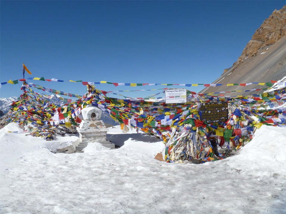
So, how far is the Annapurna Circuit trek? The honest answer: it depends. In 2026, the annapurna circuit trek distance typically ranges from about 160 km (100 miles) for a road-assisted version up to approximately 230 km (143 miles) if you walk the classic route with popular side trips like Tilicho Lake and Poon Hill. The Annapurna Circuit Trek typically takes between 12 to 22 days to complete, depending on the chosen route and itinerary variations.
Why do the numbers online conflict so dramatically? Simple—different sources count different things. Some measure only pure walking distance (excluding drives), while others include the total journey from Kathmandu to Pokhara. Starting points vary from Besisahar to Dharapani to Chame. End points swing between Muktinath and Nayapul. Add optional detours, and you’ve got a recipe for confusion.
This guide is written from the perspective of Excellent Himalaya Trek and Expedition Pvt. Ltd, based on leading dozens of groups through the annapurna region, which is centered around the Annapurna massif located in north central Nepal, every season. We’ll cut through the noise and give you the real numbers for 2026.
Quick Distance Summary:
- Short Road-Assisted Circuit: ~120–160 km (75–100 miles), 12–14 days
- Standard 14-Day Dharapani to Muktinath: ~160–180 km (100–112 miles)
- Classic Plus Tilicho & Poon Hill: ~200–230 km (125–143 miles), 16–22 days
As you review these options and prepare for your journey, keep in mind the trek ahead will offer a variety of landscapes and experiences, setting the stage for an unforgettable adventure.
The Distance Debate: Why Annapurna Circuit Trek Length is Not Fixed
Back in the 1990s, the annapurna circuit was a straightforward affair. You started walking in Besisahar, circled the annapurna massif on foot including views of Annapurna I, the highest peak in the massif at 8,091 meters, renowned as the first 8,000-meter summit ever climbed and infamous among mountaineers for its high fatality rate—crossed Thorong La Pass at 5,416 meters, and descended to Nayapul—roughly 190–200 km over 14–16 days of pure walking. The classic route is typically walked counter-clockwise to allow for proper acclimatization before crossing Thorong La Pass.
The Distance Debate: Why Annapurna Circuit Trek Length is Not Fixed
Back in the 1990s, the annapurna circuit was a straightforward affair. You started walking in Besisahar, circled the annapurna massif on foot—including views of Annapurna I, the highest peak in the massif at 8,091 meters, renowned as the first 8,000-meter summit ever climbed and infamous among mountaineers for its high fatality rate—crossed Thorong La Pass at 5,416 meters, and descended to Nayapul—roughly 190–200 km over 14–16 days of pure walking. The classic route is typically walked counter-clockwise to allow for proper acclimatization before crossing Thorong La Pass.
Then came the roads.
Since the early 2000s, jeep roads have progressively penetrated both sides of the circuit. On the east, the Marshyangdi Valley road now reaches from Besisahar through Dharapani and beyond to Chame. On the west, the Kali Gandaki Valley road connects Muktinath down through Jomsom, Tatopani, and eventually Pokhara. The trek begins with a drive from Kathmandu to Besisahar, followed by a trek that covers various villages and landscapes, culminating at Thorong La Pass, the highest point of the trek at 5,416 meters.
This road construction fundamentally changed the equation. Modern trekkers can now drive Kathmandu to Dharapani (about 200 km, 8–9 hours), walk the high-altitude core from Dharapani to Muktinath, and drive out from Jomsom to Pokhara—cutting pure walking distance to 110–170 km in 12–16 days. The total trekking distance is approximately 122 kilometers (about 76 miles) when excluding driving segments entirely.
Here’s where starting points matter: Beginning at Besisahar (760m) adds 35–40 km of walking compared to driving directly to Dharapani (1,860m). Starting at Bhulbhule adds about 20–25 km over Dharapani. Meanwhile, jumping straight to Chame (2,630m) shortens the trek by another 10–15 km from Dharapani—convenient for time-limited travelers but sacrificing early acclimatization.
Adding detours pushes totals back up. The high-route natural annapurna trekking trails from Upper Pisang through Ghyaru and Ngawal to Manang adds 10–12 km compared to the valley road. The Tilicho Lake side trip from Manang tacks on 24–30 km and 2 extra days. Walking the full Ghorepani–Poon Hill extension instead of driving from Tatopani adds another 30–35 km.
Three Real-World Options at a Glance:
- Short Road-Assisted Circuit (120–150 km): Drive to Dharapani, walk to Muktinath, fly or drive out from Jomsom. Best for 12-day itineraries and time-pressed trekkers.
- Standard 14-Day Circuit (160–180 km): Drive to Dharapani, walk through Manang and over Thorong La, partial walk to Tatopani or Ghorepani, drive to Pokhara. Ideal balance for first-timers.
- Classic Plus Tilicho & Poon Hill (200–230 km): Full walking experience with side trips to Tilicho Lake and Poon Hill sunrise viewpoint. For experienced trekkers seeking immersion.
Standard 14-Day Annapurna Circuit Trek Distance (Dharapani–Muktinath)
This is Excellent Himalaya Trek’s recommended annapurna circuit trek itinerary for 2026—designed to balance total distance, proper acclimatization, and road avoidance. We’ve refined this over seasons of guiding, and it remains our most requested option.
The structure is straightforward:
- Drive Kathmandu to Dharapani (Day 1)
- Walk Dharapani to Muktinath via Manang and Thorong La (Days 2–8)
- Walk or drive Muktinath to Tatopani/Ghorepani (Days 9–13)
- Drive Nayapul to Pokhara (Day 14)
The total walking distance in this 14-day plan typically lands between 160–175 km (100–110 miles), depending on exact overnight stops and whether you take NATT high-route alternatives. Spending more time at altitudes around 3,500 meters (11,500 feet) is crucial for successful acclimatization during high altitude trekking. A standard itinerary includes a day of acclimatization in Manang, which is crucial for adjusting to high altitudes before proceeding to higher elevations.
Let me highlight a few concrete days before we dive into the full table:
- Day 3: Chame to Upper Pisang covers approximately 17 km (10.5 miles) over 6–7 hours, entering pine forests with views of the dramatic Paungda Danda rock face.
- Day 6: Manang to Yak Kharka is about 6-8 km and takes 4-5 hours to hike—a deliberately short distance as you climb above 4,000m.
- Day 8: Thorong Phedi to Muktinath via Thorong La spans 15–18 km (9–11 miles) over 8–10 hours—the longest, toughest day of the circuit trek.
Day-by-Day Mileage Table for Our 14-Day Annapurna Circuit Itinerary
Below is our realistic day-by-day breakdown. Note that GPS tracks differ slightly by device and route choice, so we’ve used “~” to indicate approximate distances.
| Day | From – To | Distance (km) | Distance (mile) | Trekking Hours | Notes |
| 1 | Kathmandu – Dharapani (drive) | 0 walking | 0 walking | 8–9 hrs drive | Scenic drive via Besisahar along Marshyangdi River |
| 2 | Dharapani – Chame | ~15.5 km | ~9.5 miles | 5–6 hrs | Gradual ascent through lush forests, ACAP checkpoints |
| 3 | Chame – Upper Pisang | ~17 km | ~10.5 miles | 6–7 hrs | Join NATT sections, views of Paungda Danda cliff |
| 4 | Upper Pisang – Ngawal – Manang (high route) | ~19 km | ~12 miles | 7–8 hrs | High-route via Ghyaru (3,960m) & Ngawal, big elevation gain/loss, views of Annapurna II |
| 5 | Manang (acclimatization day) | ~5–10 km | ~3–6 miles | 3–5 hrs | Acclimatization hike to Gangapurna Lake or Praken Gompa, sleep again in Manang |
| 6 | Manang – Yak Kharka | ~10–11 km | ~6–7 miles | 5–6 hrs | Slow pace, crossing streams and alpine pastures |
| 7 | Yak Kharka – Thorong Phedi | ~6–7 km | ~4 miles | 4–5 hrs | Short but higher altitude, optional early morning hike towards Thorong High Camp |
| 8 | Thorong Phedi – Thorong La – Muktinath | ~15–18 km | ~9–11 miles | 8–10 hrs | Crossing Thorong La Pass (5,416m), early start, steep descent |
| 9 | Muktinath – Jomsom | ~19–21 km | ~12–13 miles | 6–7 hrs | Descend through Kagbeni (sacred pilgrimage site), arid Kali Gandaki Valley |
| 10 | Jomsom – Marpha – Tukuche | ~15 km | ~9 miles | 5–6 hrs | Flexible day along old footpaths and apple orchards |
| 11 | Tukuche – Ghasa | ~18 km | ~11 miles | 6–7 hrs | Gradual descent, warmer subtropical shift, traditional villages |
| 12 | Ghasa – Tatopani | ~15–17 km | ~9–10.5 miles | 6–7 hrs | Enter lush subtropical forests; evening soak in natural hot springs |
| 13 | Tatopani – Ghorepani | ~15–16 km | ~9–10 miles | 7–8 hrs | Big uphill day, steady ascent through rhododendron forest |
| 14 | Ghorepani – Poon Hill – Nayapul – Pokhara | ~18–20 km walking | ~11–12 miles | 7–8 hrs walk + 1.5–2 hrs drive | Sunrise at Poon Hill (3,210m), long descent to roadhead |
Total Estimated Walking Distance: 160–175 km (100–110 miles)
The circuit features roughly 10,000–12,000 meters of total ascent and about 14,000 meters of descent—a significant elevation profile that makes horizontal distance somewhat deceptive. We’ll address this terrain reality in detail below. Manang, located at 3,540 meters (11,614 feet), serves as an ideal acclimatization stop due to its altitude, facilities, and hiking options—including trails to ancient monasteries and viewpoints of surrounding peaks.
Tilicho Lake Side Trip: A 4-Day Detour for Adventure Seekers
If you are looking to deepen their Annapurna Circuit experience, the Tilicho Lake side trip is a must. As our experience it is a bit challenging detour which adds roughly 25–30 km (15–19 miles) and 3 extra days of trekking, making it a 4-day excursion from Manang.
Day 1: Manang to Shree Kharka
Distance: ~10 km (6.2 miles)
Trekking Hours: 4–5 hours
Starting from Manang (3,540m), the trail gradually ascends through alpine meadows and traditional Tibetan villages to Shree Kharka (4,200m). This moderate day helps with acclimatization while preparing for the more demanding terrain ahead.
Day 2: Shree Kharka to Tilicho Base Camp
Distance: ~7 km (4.3 miles)
Trekking Hours: 4–5 hours
The trail climbs steadily to Tilicho Base Camp (4,150m), nestled beneath towering peaks. This section requires steady pacing to manage the altitude gain and navigate rocky terrain and moraines.
Day 3: Tilicho Base Camp to Tilicho Lake and back to Shree Kharka
Distance: ~14 km (8.7 miles)
Trekking Hours: 7–8 hours
The highlight of the side trip, this day involves a steep climb to Tilicho Lake (4,919m), one of the world’s highest alpine lakes. The breathtaking turquoise waters framed by snow-capped peaks reward your effort. After soaking in the scenery, you descend back to Shree Kharka for an overnight stay.
Day 4: Shree Kharka to Yak Kharka and rejoin the main Annapurna Circuit trail
Distance: ~10 km (6.2 miles)
Trekking Hours: 5–6 hours
This day involves descending from Shree Kharka to Yak Kharka (4,050m), a yak pasture settlement, where you rejoin the main Annapurna Circuit route towards Thorong La Pass. The trail passes through rhododendron forests and offers sweeping views of the surrounding peaks.
Important Tips for Tilicho Lake Trek:
- This side trip is best suited for well-acclimatized and physically
Key Route Variations and How They Change the Distance
The annapurna circuit distance varies from 160 to 230 kilometers (100 to 143 miles) depending on the chosen route and any side trips taken. That’s not imprecision—it’s customization. Here’s how each decision shifts your trekking distance.
Starting Point Variations: Walking the full lower section from Besisahar to Dharapani adds roughly 35–40 km (22–25 miles) compared to driving. Starting at Bhulbhule adds 20–25 km over Dharapani. Beginning at Chame saves another 10–15 km but sacrifices valuable low-altitude acclimatization days through the Marshyangdi gorge and terraced villages.
Ending Point Variations: The classic route descends from Muktinath all the way to Nayapul—about 80–100 km of post-pass walking through the Kali Gandaki Valley, Tatopani’s hot springs, and Ghorepani. Many trekkers shorten this by driving from Muktinath or Jomsom to Tatopani (saving 60–70 km) or flying directly from Jomsom to Pokhara (saving the entire western descent).
Poon Hill Extension: The Poon Hill trek from Tatopani adds roughly 30–35 km and 2 days, including the steep ascent to Ghorepani and the early morning hike to the viewpoint at 3,210m. For trekkers skipping this extension, the walking distance drops by about 30 km, but you miss one of Nepal’s most iconic sunrise panoramas over the annapurna mountain range and Dhaulagiri.
Tilicho Lake Side Trip: Adding Tilicho Lake from Manang typically adds about 25–30 km (15–19 miles) and 3 extra days of trekking. The trail passes through Khangsar, climbs to Tilicho Base Camp (4,150m), then summits at Tilicho Lake (4,919m)—one of the world’s highest lakes. This challenging trek extension is best suited for well-acclimatized, fit trekkers.
When comparing the Annapurna Circuit to other famous treks like the Everest Base Camp trek, it’s worth noting that the everest region is another remote and adventurous area in Nepal. The Everest region offers unique trekking experiences, such as the Gokyo Lakes Trek, and is considered a hidden gem of the Himalayas for those seeking more exclusive and challenging expeditions.
Itineraries by Distance:
| Duration | Distance Range | Best For |
| 12 days | 100–120 km (62–75 mi) | Time-limited travelers, drives on both ends, no Poon Hill |
| 14 days | 160–180 km (100–112 mi) | First-timers, balanced acclimatization, standard annapurna circuit route |
| 16 days | 180–200 km (112–125 mi) | Including Tilicho Lake OR full Poon Hill extension |
| 18–22 days | 200–230 km (125–143 mi) | Full classic plus all side trips, strong trekkers seeking complete immersion |
The Short Annapurna Circuit can cover between 62 to 100 miles (100 to 160 kilometers), depending on the route and available transportation, a good option for those with limited vacation days who still want the core annapurna circuit adventure experience.
The Guide’s Secret: Best NATT Sections to Avoid the Roads
Here’s what most online guides won’t tell you: the natural annapurna trekking trails (NATT) exist specifically to help trekkers avoid the dusty jeep roads that have spread across the annapurna area since the 2000s. These purpose-built alternatives, developed by local communities and TAAN (Trekking Agencies’ Association of Nepal), are marked with red/white or blue/white stripes painted on rocks and trees.
At Excellent Himalaya, our guides know these routes intimately—and they’re the secret to transforming a road-heavy slog into a proper mountain experience. The trade-off? You’ll walk 2–5 km more per day. The payoff? Dramatically better mountain views, quieter trails, and traditional villages untouched by traffic.
The High Route: Upper Pisang – Ghyaru – Ngawal – Manang
This is the single most important NATT section on the entire circuit trek. Instead of following the road along the valley floor from Pisang to Manang (about 16 km), the high route climbs steeply from Upper Pisang to Ghyaru (3,960m), traverses to Ngawal (3,660m), and descends to Manang (3,540m)—totaling 19–25 km depending on exact routing.
The extra 10–12 km and 600m of additional ascent rewards you with unobstructed views of Annapurna II, Annapurna III, Annapurna IV, and Gangapurna that are completely hidden from the lower road. You’ll walk through old Tibetan-Buddhist villages with ancient monasteries, prayer wheels, and chortens. This section alone makes hiring a local guide worthwhile—the trail markings can be faint, and recent landslides occasionally obscure paths.
Chame to Pisang Pine Forest Trails
Between Chame and Pisang, NATT alternatives climb through old-growth pine forests and bypass several jeep-road switchbacks. These add 2–3 km but keep you on the traditional trekking trail used before the road was built.
Jomsom to Marpha Apple Orchard Paths
The Kali Gandaki Valley section from Jomsom to Marpha to Tukuche can be walked almost entirely on old footpaths through apple orchards and traditional villages, rather than on the dusty main road. These off-road options add 3–5 km but offer shade, local culture, and far less vehicle dust.
Tatopani to Ghorepani Stone Steps
The steep ascent from Tatopani to Ghorepani features original stone-stepped paths through lush subtropical forests that diverge from the newer road. These ancient trails through rhododendron groves add 2–4 km but provide the quintessential diverse landscapes of the annapurna sanctuary region.
Must-Not-Miss NATT Sections:
- Upper Pisang – Ghyaru – Ngawal – Manang high route (+10–12 km)
- Chame – Upper Pisang pine forest NATT (+2–3 km)
- Jomsom – Marpha orchard footpaths (+3–5 km)
- Tatopani – Ghorepani stone-stepped forest trails (+2–4 km)
- Sikha – Chitre alternative via Poon Hill viewpoint ridge (+2–3 km)
Terrain & Technicality: Why Distance Feels Longer on the Annapurna Circuit
A 15 km day in the annapurna region is not the same as 15 km on a city trail. The varied terrain, steep ascents, rocky paths, and thin air above 3,500m combine to make horizontal distance a poor measure of actual effort. Distance at high altitudes (above 3,500m) is often measured in hours rather than kilometers—and for good reason.
Physical fitness is crucial for the Annapurna Circuit trek, as it involves significant elevation changes and challenging terrain, requiring trekkers to be well-prepared for long days of hiking. Training should include cardiovascular exercises such as running, swimming, and hiking to build endurance and strength, ideally starting 2-3 months before the trek.
The Thorong La Approach:
Above Manang, the terrain transforms. You leave behind the relatively gentle trails of the lower circuit and enter an alpine world of glacial valleys, loose scree, and frozen streams. The section from Yak Kharka to Thorong Phedi crosses old moraines—bouldery glacial debris that demands careful foot placement with every step.
On pass day itself, you’ll climb from Thorong Phedi (4,450m) to High Camp (4,920m), then tackle 500 meters of relentless zigzagging switchbacks to the pass (5,416m). At this altitude, oxygen levels are roughly 50% of what you’d breathe at sea level. A distance that might take 2 hours at lower elevation can demand 5–6 hours here.
The Math of Effort:
Consider two contrasting days:
- Day 9 (Muktinath to Jomsom): 19–21 km, relatively flat Kali Gandaki Valley floor. Walking pace: 3–5 km/hr. Total time: 6–7 hours.
- Day 7 (Yak Kharka to Thorong Phedi): Just 6–7 km, but 400m elevation gain at 4,000m+. Walking pace: 1.5–2 km/hr. Total time: 4–5 hours. Effort equivalent: 15–20 km on flat ground.
Acclimatization is essential for preventing altitude sickness, which can occur at high elevations due to lower oxygen levels. The circuit’s design—walking counter-clockwise with gradual gains and an acclimatization day in Manang—follows the “climb high, sleep low” principle that minimizes AMS risk.
Practical Tips for Managing the Terrain:
- Pace yourself: Maintain 2–3 km/hr above 4,000m; faster is unsustainable and risky
- Use trekking poles: They provide 20–30% more stability on descents and reduce knee strain over the total distance
- Hydrate aggressively: 4–5 liters of water daily at altitude, plus electrolytes
- Fuel frequently: Dal bhat (lentils and rice) provides sustained energy; eat before you’re hungry
- Start early on pass day: Depart Thorong Phedi by 4–5 AM to cross before afternoon winds of 30–50 km/h
- Wear proper hiking boots: Ankle support is essential for loose tephra and rocky moraines
Logistics & Trust: Why Trek the Circuit with Excellent Himalaya Guides
Since Nepal’s 2023 regulation changes, all foreign trekkers must trek with a licensed guide in the Annapurna Conservation Area. This isn’t bureaucracy for its own sake—the trail network has genuinely become more complex with roads, NATT alternatives, and changing conditions.
At Excellent Himalaya Trek and Expedition, we offer more than permit processing. Our guides provide real-time navigation through a trail system that changes seasonally. They know which NATT sections are clear, which road stretches are worth driving, and where landslides may have altered the trail passes since last season.
Practical Advantages of Our Guides:
Our guides local experience keep you within a comfortable 10–18 km per day depending on altitude and fitness. On days when altitude sickness symptoms appear or weather turns, guides can restructure plans—arranging jeep transport ($50–100 per segment), hiring horses for tired legs ($25/day), or extending rest days without losing the overall itinerary.
We handle logistics that would otherwise consume your planning energy: Annapurna Conservation Area Permit (ACAP) processing, TIMS card registration, and coordination with roughly 50 checkposts along the route. When the trail ahead is blocked by snow on Thorong La (common November–December) or landslides above Yak Kharka (monsoon risk), our guides execute contingency routes.
What We Provide:
- Custom itineraries: 12-day, 14-day, 16-day, with or without Tilicho Lake extension
- Strategic road transport to skip dusty, traffic-heavy stretches
- Teahouse bookings at ideal spacing for long distance hiking and proper acclimatization
- Daily health and AMS monitoring using standard protocols
- Real-time distance tracking and pace adjustment
- Emergency protocols including helicopter evacuation contacts
For your 2026 annapurna circuit trek package, contact Excellent Himalaya to discuss your available days, fitness level, and whether you want to include Tilicho Lake, Poon Hill, or both. We’ll craft a distance plan that matches your goals—whether that’s 120 km of highlights or 230 km of complete immersion in north central Nepal’s most spectacular trekking routes.
FAQ: Annapurna Circuit Trek Distance in Practice
These are the questions trekkers ask us most frequently—answered directly based on guiding experience across every version of the circuit.
Can I skip the road sections?
Absolutely. Most of our 2026 itineraries incorporate strategic road transport. You can drive Besisahar to Dharapani (saving 35–40 km of dusty low-altitude walking), or even directly to Chame (saving another 15 km). On the exit, you can drive from Muktinath to Jomsom (20 km), Jomsom to Tatopani (70 km), or fly Jomsom to Pokhara (25 minutes vs. 5 days walking). Each choice changes your total trekking distance and required days. A typical “maximum road assist” version covers about 100–120 km of walking in 12 days. The standard 14-day version walks 160–175 km. The full classic route with minimal driving spans 200+ km.
How many miles or kilometers do we walk per day?
Expect daily distances ranging from 10–18 km (6–11 miles), with significant variation by altitude and terrain. Low-altitude valley days (like Muktinath to Jomsom) can cover 18–21 km in 6–7 hours at 3–5 km/hr. High-altitude days (like Yak Kharka to Thorong Phedi) cover just 6–8 km in 4–5 hours at 1.5–2 km/hr. Pass day spans 15–18 km but requires 8–10 hours due to the massive elevation change and thin air. Acclimatization day hikes around Manang cover 5–10 km.
Is the Annapurna Circuit longer than the Everest Base Camp trek?
Yes, typically by 30–70 km. The classic Everest Base Camp trek covers approximately 120–130 km (75–80 miles) over 12–14 days, with a highest point at Kala Patthar (5,644m) rather than a pass crossing. The standard annapurna circuit covers 160–180 km. The key difference beyond pure distance: the Annapurna Circuit’s diverse landscapes span lush subtropical forests to high-altitude desert, while EBC stays within the everest region’s Sherpa cultural zone. The Annapurna Sanctuary Trek (to Annapurna Base Camp) is shorter at about 110 km but offers a different experience entirely, approaching Mount Annapurna and Annapurna South from within the glacial bowl of the annapurna sanctuary.
How many days do I really need?
Minimum: 12 days (road-heavy, AMS-risky, 100–120 km walking). Optimal: 14 days (balanced acclimatization, 160–175 km, ideal for first-timers). Comfortable: 16–18 days (includes Tilicho Lake or full Poon Hill extension, 180–200 km). Luxurious: 20–22 days (complete classic plus all side trips, 200–230 km, for those seeking full immersion in the annapurna mountains).
What if I get tired and want to shorten the distance mid-trek?
This is precisely why traveling with experienced guides matters. Local jeeps operate between most villages from Dharapani to Jomsom and are available on short notice ($50–100 per segment). Horses can be hired in certain areas like Kagbeni to Muktinath. From Jomsom, daily flights to Pokhara ($120–150) offer an immediate exit if needed. Our guides restructure plans safely—ensuring you don’t miss critical acclimatization days or strand yourself in a village without transport.
Planning Your 2026 Annapurna Circuit:
- Share your available days and fitness level with us
- Decide whether you want Tilicho Lake, Poon Hill, or both
- Consider your tolerance for road walking vs. jeep transport
- Let Excellent Himalaya craft the optimal total trekking distance for your annapurna circuit adventure
Whether you’re aiming for a 12-day efficient circuit or a 20-day complete journey through every ecological zone from the Kathmandu Valley lowlands to the Tibetan Plateau highlands, understanding the real distances helps you pack the right expectations alongside your trekking boots.
Ready to plan your 2026 Annapurna Circuit? Contact Excellent Himalaya Trek and Expedition Pvt. Ltd today. We’ll help you determine the perfect itinerary, build in proper acclimatization at the highest point of your trek, and create an itinerary that matches your goals whether you’re chasing snow capped peaks, seeking the steady climb to Thorong La, or simply want to experience one of the world’s greatest high altitude trekking routes without the confusion.
Ask our experts (Inquiry)
Why Travel with us?
- Run by local experts, guide & Sherpa.
- Focus on your needs.
- Good value for money.
- Real cared services.
- Government recognized company.
- Best reasonable rate.