



Gokyo Lake Trek Distance: A Day-by-Day Route & Altitude Guide
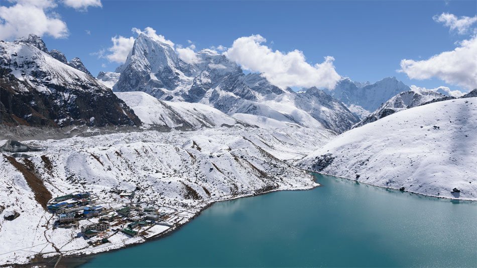
The classic gokyo lake trek from Lukla covers approximately 92–100 km round-trip. Add side trips like the fifth lake or renjo la pass, and you’re looking at 110 km or more. These numbers sound manageable on paper—until you factor in that every step above 4,500 m demands roughly twice the effort of walking at sea level.
At Excellent Himalaya Trek and Expedition Pvt. Ltd, our senior guides have led over 40 expeditions to the turquoise lakes of the gokyo valley, a highlight of the popular Gokyo Ri trek for trekkers seeking panoramic Himalayan views. We’ve watched experienced trekkers underestimate “short” 8 km days and seen first-timers thrive because they understood what the Gokyo Ri Lakes Trek distance really means at altitude. This guide breaks down the kilometers, the elevation gains, and the terrain so you can plan your 2026 journey with realistic expectations.
The focus here isn’t just “how many days” but how far you’ll walk each day, at what altitude, and why even modest distances become demanding when the air holds half the oxygen you’re used to breathing. We prioritize acclimatization over speed because reaching gokyo ri at 5,357 m matters only if you arrive healthy enough to enjoy the view.
Introduction to the Gokyo Lakes Trek
The Gokyo Lakes Trek is one of Nepal’s most spectacular high-altitude adventures, winding through the heart of the Everest region and offering a quieter, more contemplative alternative to the classic Everest Base Camp trek. This remarkable trekking route leads you deep into the Gokyo Valley, a hidden gem renowned for its chain of turquoise lakes, dramatic glacial landscapes, and sweeping views of the Himalayan mountain ranges—including the towering peaks of Mount Everest, Cho Oyu, and Makalu.
Unlike the busier Everest Base Camp trail, the Gokyo Lake trek immerses you in serene alpine valleys dotted with traditional Sherpa villages and ancient monasteries. As you ascend through the Sagarmatha National Park, you’ll experience the rich tapestry of Sherpa culture, passing prayer-flag-draped chortens and yak pastures framed by snow capped peaks. The trek passes through a series of picturesque settlements, each offering a glimpse into the daily life and hospitality of the Khumbu region’s mountain communities.
High altitude trekking is at the core of the Gokyo route, with steep ascents and challenging sections that require a moderate level of physical fitness and, ideally, some prior trekking experience. The journey rewards your effort with panoramic vistas from vantage points like Gokyo Ri, where the entire Everest massif unfolds before you, and the shimmering turquoise lakes reflect the grandeur of the surrounding peaks.
For those seeking both adventure and tranquility, the Gokyo Valley trek delivers a perfect blend of natural beauty, cultural immersion, and the thrill of exploring one of the world’s most breathtaking alpine landscapes. Whether you’re drawn by the allure of the turquoise lakes, the spiritual atmosphere of ancient monasteries, or the promise of snowcapped Himalayan horizons, the Gokyo Lake trek stands out as a must-do experience in the Everest region.
Total Gokyo Lake Trek Distance Overview
The standard gokyo lake circuit—Lukla to Gokyo and back—covers approximately 92–100 km. This is the core trekking route most operators quote, and it includes the main objective: reaching gokyo village at 4,790 m and ascending gokyo ri for panoramic views of the himalayan mountain ranges.
However, the gokyo trek rarely stays at 92 km. Most trekkers add at least one major side trip, which extends the total distance:
- Lukla–Gokyo–Lukla with Gokyo Ri only: ~95–98 km total
- Adding Fifth Lake (Ngozumpa Tsho): +7–9 km round trip, bringing total to ~102–107 km
- Renjo La Pass loop (via Thame and Marlung): +10–15 km, totaling ~105–112 km
- Combined Fifth Lake + Renjo La extension: 110–115 km or more
- Cho La Pass extension (5,420 m): This high-altitude pass is often included in extended treks, connecting the Gokyo route to the Everest Base Camp trail for a more adventurous circuit.
The gokyo route diverges from the everest base camp trail at Sanakhar, just past namche bazaar. From there, you enter quieter alpine valleys with fewer trekkers and lodges. While the everest base camp trek covers roughly 130 km over 14 days, the gokyo valley trek achieves comparable scenery—views of mount everest, Lhotse, Makalu, and cho oyu—in approximately 110 km over 11–14 days.
Gokyo vs. EBC: A Quick Comparison
| Factor | Gokyo Lake Trek | Everest Base Camp Trek |
| Round-trip distance | 92–110 km | ~130 km |
| Typical duration | 11–14 days | 12–16 days |
| Total elevation gain | ~2,500 m | ~2,500 m |
| Crowd levels | 20–30% less traffic | Peak-season congestion |
| Highest point | Gokyo Ri (5,357 m) | Kala Patthar (5,545 m) |
The gokyo lake trek offers an equally dramatic Everest panorama with significantly fewer people on the trail. For trekkers seeking solitude alongside their summit views, the gokyo valley delivers.
026 Flight & Access Logistics: Where the Distance Really Starts
Before you walk a single kilometer of the gokyo trek, you need to reach Lukla. In 2026, during peak trekking seasons (March–May and October–November), most flights to Lukla operate via Manthali (Ramechhap) rather than directly from Kathmandu.
This logistical shift, formalized post-2019 to manage air traffic at Lukla’s single-runway airport, adds a significant travel component before trekking distance begins:
- Kathmandu to Manthali: 4–5 hour drive (130–150 km by road), typically departing at 2–3 AM
- Manthali to Lukla: 20–25 minute twin-otter flight
- Total travel time: 8–10 hours before you set foot on the trail at Lukla (2,860 m)
Key logistics for 2026 trekkers:
- During shoulder seasons (December–February, June–September), direct Kathmandu–Lukla flights (30–35 minutes) may still operate, subject to weather and demand
- Historical data shows 20–30% flight cancellation rates due to fog or monsoon conditions—build buffer days into your schedule
- 2026 may see upgraded Manthali facilities and 10–15 daily flights during peak seasons, but risks persist
At Excellent Himalaya Trek, we arrange private vehicles or chartered buses departing Kathmandu at 2–3 AM, ensuring arrival in Lukla by noon for rest. This early departure protects your sleep cycle and gives you time to acclimatize before the trek officially begins.
Important clarification: All trekking distances in this guide are measured from Lukla onwards. The 4–5 hour drive and early morning scenic flight add travel time, not trekking kilometers.
Day-by-Day Gokyo Lake Trek Distance & Altitude (Standard Route)
Below is a typical 12–13 day itinerary for the Lukla–Gokyo–Lukla circuit. Distances, walking hours, and altitudes reflect realistic conditions based on our guides’ GPS tracks and decades of on-trail experience.
| Day | Route | Distance | Walking Hours | Start → Max Altitude |
| 1 | Lukla to Phakding | 8–9 km (5 mi) | 3–4 hrs | 2,860 m → 2,610 m |
| 2 | Phakding to Namche Bazaar | 11–12 km (6.8 mi) | 5–6 hrs | 2,610 m → 3,440 m |
| 3 | Namche Acclimatization Day | 4–8 km | 3–4 hrs | 3,440 m → 3,880 m |
| 4 | Namche to Dole (via Mong La) | 7–11 km | 5–6 hrs | 3,440 m → 4,038 m |
| 5 | Dole to Machhermo | 5–9 km | 4–5 hrs | 4,038 m → 4,470 m |
| 6 | Machhermo to Gokyo | 7–8 km | 4–5 hrs | 4,470 m → 4,790 m |
| 7 | Gokyo Ri + Optional Fifth Lake | 3.6–10 km | 4–7 hrs | 4,790 m → 5,357 m |
| 8 | Gokyo to Dole | 10–12 km | 5–6 hrs | 4,790 m → 4,038 m |
| 9 | Dole to Namche Bazaar | 11 km | 5–6 hrs | 4,038 m → 3,440 m |
| 10 | Namche to Lukla | 18–19 km | 6–7 hrs | 3,440 m → 2,860 m |
Day-by-day breakdown:
Day 1: Lukla to Phakding (8–9 km, 3–4 hours) A gentle introduction along the dudh koshi river valley. The trail winds through pine forests and crosses several suspension bridges, giving you time to find your rhythm at moderate altitude. Net elevation: -200 m.
Day 2: Phakding to Namche Bazaar (11–12 km, 5–6 hours) The trek’s first major challenge. After crossing the famous Hillary Suspension Bridge, the trail climbs steeply to namche bazaar altitude of 3,440 m. This 800 m ascent tests your conditioning early.
Day 3: Namche Acclimatization Day (4–8 km, 3–4 hours) A mandatory rest day with optional hikes. Popular routes include the everest view hotel (3,880 m) or the sherpa museum in Khumjung. These acclimatization hikes—climb uphill during the day, sleep low at night—are essential for AMS prevention.
Day 4: Namche to Dole (7–11 km, 5–6 hours) The trail diverges from the everest base camp route at Sanakhar. Dusty switchbacks lead through rhododendron forests to Mong La Pass (4,000 m) before descending to Dole. You’ll pass through quiet sherpa villages with fewer lodges than the EBC trail.
Day 5: Dole to Machhermo (5–9 km, 4–5 hours) A gentler day through yak pastures and open valley. This is your first sustained exposure to 4,000 m+, and the gradual ascent helps your body adjust before the more demanding terrain ahead.
Day 6: Machhermo to Gokyo (7–8 km, 4–5 hours) The most technically challenging day. The trail traverses the ngozumpa glacier’s lateral moraines—loose rock, steep undulations, and a key iron bridge crossing before the final approach to gokyo village.
Day 7: Gokyo Ri and/or Fifth Lake (3.6–10 km, 4–7 hours) Summit day. The 3.6 km round trip to gokyo ri peak gains 567 m on steep switchbacks. The fifth lake extension adds another 7–9 km on gentler terrain above 5,000 m.
Return Days (8–10): Descent follows the same route in reverse but moves faster downhill. The final day from Namche to Lukla covers 18–19 km—the longest single-day distance of the entire trek.
Excellent Himalaya Trek’s adaptive approach:
We monitor every client’s oxygen saturation from Namche onwards. If readings drop below 85% or mild AMS symptoms appear, we insert an extra night in Dole or Machhermo. Shortening distances when necessary isn’t a setback—it’s how we maintain a 95% summit success rate across 40+ expeditions.
The Ngozumpa Glacier Factor: How Terrain Affects Distance
The ngozumpa glacier stretches 36 km from Cho Oyu’s eastern flank, making it the longest glacier in Nepal. For trekkers, it presents a unique challenge: the “mapped” distance from Machhermo to gokyo village (7–8 km) feels considerably longer than the numbers suggest.
Why the Machhermo–Gokyo leg is harder than it looks:
- Lateral moraine navigation: The trail crosses unstable talus slopes where loose scree and rocks shift underfoot
- Constant undulations: 50–100 m ups and downs across the moraine, not a steady climb
- Narrow, shifting paths: Glacier movement (20–30 m per year) reconfigures routes seasonally, with trails shifting 10–20% from year to year
- Technical crossings: An iron bridge spans turbulent glacial streams, followed by boulder fields requiring careful foot placement
The final approach to Dudh Pokhari (the Third Lake, 4,700 m+) delivers your first view of the turquoise lakes that define the gokyo lake trek. The turquoise hue—caused by glacial sediment suspended in meltwater—appears suddenly as you crest the last moraine ridge, with Cho Oyu’s massive face reflected in the still water.
Real-world distance adjustments:
GPX tracks from previous seasons often show 0.5–1 km variation from current routes. Scientific studies on Himalayan moraines confirm unstable terrain increases both fall risk and actual distance walked as guides scout the safest seasonal paths.
Our guides walk the Machhermo–Gokyo section before each season’s first group arrives, mapping current conditions. This local knowledge—unavailable from GPS apps that lag real-time changes—ensures we set accurate time expectations even when the numeric distance looks “short” on paper.
Gokyo Ri & Fifth Lake Distances: The High-Altitude Side Trips
The gokyo ri distance from gokyo village to summit is approximately 3.5–3.8 km round trip. That’s shorter than many morning jogs—yet climbing gokyo ri typically takes 4–6 hours and represents the most physically demanding stretch of the entire trek.
Gokyo Ri (5,357 m): The Numbers
| Metric | Value |
| Round-trip distance | 3.5–3.8 km |
| Elevation gain | 567 m |
| Average gradient | 15–20% |
| Ascent time | 2–4 hours |
| Descent time | 1.5–2 hours |
| Oxygen level at summit | ~50% of sea level |
The steep ascents over loose shale demand the rest-step technique—pausing briefly on your planted foot with each step to let your muscles recover. At 5,357 m, your breathing rate doubles and your VO2 max drops roughly 30% compared to sea level.
What you see from the summit:
The gokyo ri peak delivers a 360-degree panorama of the “Big Four” 8,000-meter peaks:
- Mount Everest (8,848 m)
- Lhotse (8,516 m)
- Makalu (8,485 m)
- Cho Oyu (8,188 m)
Below, the ngozumpa glacier’s tongue flows between snow capped peaks, with the chain of five turquoise lakes stretching northward. Dudh Pokhari dominates the foreground, its intense blue contrasting with the glacier’s gray moraine. Many guides consider this viewpoint superior to Kala Patthar on the EBC route because you see both the snowcapped peaks and the lakes in a single frame.
Fifth Lake Extension (Ngozumpa Tsho)
| Metric | Value |
| Round-trip from Gokyo | 7–9 km |
| Walking time | 4–5 hours |
| Maximum altitude | ~5,000 m |
| Terrain | Gentle undulating tundra |
The trek passes the fourth and first gokyo lake before reaching Thonak Tsho (Fourth Lake, the largest at 4.6 km long) and finally Ngozumpa Tsho. The gradient is gentle, but elevation above 5,000 m means even experienced trekkers move slowly.
Expert Tip: In terms of perceived effort per kilometer, the ascend gokyo ri stretch is the hardest of the entire trek. Many trekkers combine both summit and fifth lake in a single 10 km, 7-hour day—but only if acclimatization has gone well. If you’re showing any acute mountain sickness symptoms, the fifth lake adds risk without proportional reward.
How Distance & Altitude Combine to Create Difficulty
The gokyo lake trek difficulty is often rated “moderate” by trekking agencies—and technically, that’s accurate. There are no technical climbing sections, no ropes, no crampons. But “moderate” understates the physiological challenge of walking 8–12 km daily at altitudes where every breath delivers half the oxygen you’re used to.
Daily distance bands:
- Short days (3–8 km): Acclimatization hikes, Gokyo Ri summit
- Medium days (7–12 km): Most trail sections between villages
- Long day (18–19 km): Namche to Lukla descent
Altitude progression:
| Location | Elevation |
| Lukla (start/end) | 2,860 m |
| Namche Bazaar | 3,440 m |
| Dole | 4,038 m |
| Machhermo | 4,470 m |
| Gokyo Village | 4,790 m |
| Gokyo Ri (summit) | 5,357 m |
| Renjo La Pass (optional) | 5,360 m |
The effort multiplier:
At sea level, a fit hiker covers 10 km in 2–2.5 hours. Between Dole and Machhermo (4,000–4,500 m), that same 10 km takes 5–6 hours. Your heart rate elevates, breathing becomes labored, and recovery between steep ascents takes longer.
High altitude trekking research shows VO2 max drops approximately 30% for every 1,000 m gained above 1,500 m. By the time you’re walking at 4,800 m, your aerobic capacity is roughly 60% of normal. This is why guides slow the pace above 3,500 m regardless of how “short” the day’s trek distance appears.
The descent challenge:
The 18–19 km final day from Namche to Lukla involves 1,500 m of elevation loss. While downhill sounds easier, the sustained pounding on knees and ankles—often on slippery trails after overnight frost—makes trekking poles essential gear. Many trekkers find this day more taxing than any uphill section.
Permits, Regulations & What They Mean for Your Route
Permits don’t change the gokyo lake trek distance, but they define the legal boundaries of where you can walk. All kilometers in this guide fall within sagarmatha national park and Khumbu Pasang Lhamu Rural Municipality boundaries.
Required permits for 2026:
- Khumbu Pasang Lhamu Rural Municipality Entry Permit
- Cost: NPR 500 (~USD 4)
- Purchase location: Lukla or Monjo
- Checkpoints: Monjo, Namche Bazaar
- Sagarmatha National Park Entry Permit
- Cost: NPR 3,000 (~USD 22)
- Purchase location: nepal tourism board office in Kathmandu or Monjo gate
- Purpose: Conservation of the Gokyo Lakes Ramsar wetland ecosystem
TIMS card status:
As of 2023, TIMS (Trekkers’ Information Management System) cards are not required for most Khumbu region routes, including the gokyo valley trek. However, regulations can change. Excellent Himalaya Trek monitors permit requirements and provides updated guidance for all 2026 departures.
Checkpoint locations:
- Monjo (entering Sagarmatha National Park)
- Namche Bazaar (secondary verification)
- Occasional random checks on the trail
Keep permits accessible in a waterproof pouch. Guards at checkpoints verify documentation for every trekker, whether solo or with a group. The trek passes through one of Nepal’s most protected ecosystems—these permits fund conservation of the scenic landscapes, ancient monasteries, and wildlife that make the khumbu region extraordinary.
Safety, Acclimatization & Our Guide-to-Client Ratio
Managing distance sensibly is a safety strategy, not just a fitness consideration. The gokyo lake trek requires careful attention to altitude sickness—a risk that affects 20–40% of unacclimatized trekkers above 3,500 m. Wearing trekking pants is essential for protection and comfort during high-altitude trekking, as they help manage weather variations, moisture, and provide warmth and mobility on challenging trails.
Excellent Himalaya Trek’s guide-to-client protocol:
| Guide Ratio | Porter Support Ratio |
| 1 guide : 5 trekkers | 1 porter shared by 2 trekkers |
| 1 guide & 1 Sherpa (assistant): 6 to 10 trekkers | 1 porter shared by 2 trekkers |
| 1 guide & 2 Sherpa (assistant): 1 to 15 trekkers | 1 porter shared by 2 trekkers |
Oximeter monitoring:
From Namche onwards, our guides check oxygen saturation (SpO2) and heart rate nightly using pulse oximeters. Key thresholds:
- SpO2 above 90%: Normal acclimatization, proceed as planned
- SpO2 70–90%: Monitor closely, consider extra rest day
- SpO2 below 75%: Triggers immediate descent protocol
We pay special attention at Machhermo (4,470 m) and Gokyo (4,790 m), where sleeping altitudes are highest. Symptoms of acute mountain sickness—headache, nausea, dizziness, loss of appetite—are taken seriously regardless of SpO2 readings.
Acclimatization policy:
- Mandatory: One full acclimatization day in Namche Bazaar with guided hikes to higher elevations
- Recommended: Extra night in Dole or Machhermo for trekkers with prior trekking experience at lower altitudes or those showing early AMS symptoms
- Flexible: We may shorten or skip side trips (fifth lake, renjo la pass) if adding distance above 5,000 m would compromise client safety
Our 40+ expedition data shows 95% summit success rates when following the “climb high, sleep low” principle. The key is recognizing that success on the gokyo trek isn’t measured by how fast you cover kilometers—it’s measured by whether you reach gokyo ri healthy and return safely.
From a Senior Guide’s Perspective: Making Each Kilometer Count
After leading dozens of treks through the gokyo valley, we’ve learned that the kilometers on a map tell only part of the story. The real measure is how those kilometers feel as you walk them.
Expert Tip: Many trekkers underestimate “short” days. The steep climb to Namche (800 m gain over 11 km), the glacier moraine approach to Gokyo (7 km of unstable terrain), and the relentless switchbacks up gokyo ri (3.6 km, 567 m gain) demand more than their distances suggest. Prepare for these sections specifically.
What the trail reveals:
The dudh koshi river changes character as you gain altitude. Near Phakding, it runs milky-white with glacial sediment, roaring through narrow gorges. By the time you’re above Namche, tributaries clear as the gradient steepens. Crossing the Hillary Suspension Bridge, you’ll see yak caravans descending with supplies—a reminder that this route has sustained sherpa culture for generations.
Along the way, you’ll have the chance to visit ancient monasteries in villages like Tengboche and Thame, where you can observe Buddhist rituals, see colorful prayer flags fluttering, and pass mani stones inscribed with prayers. The Sherpa culture is deeply intertwined with Tibetan Buddhism, and these spiritual sites offer a window into their traditions and daily practices.
Between Dole and Machhermo, the valley opens into wide yak pastures. The trail winds through tundra where grazing animals outnumber trekkers. It’s quiet here—none of the lodge congestion of the EBC trail. You can hear the wind and the distant rumble of ice calving from glaciers.
The first view of Dudh Pokhari catches everyone off guard. You crest a moraine ridge expecting more gray rock, and suddenly there’s this impossible turquoise—deeper than photos suggest, reflecting Cho Oyu’s snow-covered mountains in perfect stillness. This is why people walk 100 km.
Pacing techniques we teach:
- Rest-step: Pause briefly on your planted foot before each step above 4,000 m. This gives your muscles micro-recovery moments.
- Pressure breathing: Exhale forcefully through pursed lips to expel CO2 and improve oxygen uptake.
- Hydration: 3–4 liters daily minimum. Dehydration mimics and worsens altitude sickness symptoms.
- Pole technique: Trekking poles aren’t just for balance—they transfer 25% of effort to your arms on steep ascents and protect knees on descent.
We encourage trekkers to ascend slowly even when they feel strong. The goal isn’t to prove fitness—it’s to let your body adapt. Some of our most successful clients are those who embrace the Sherpa pace: steady, unhurried, present.
The real success of the gokyo lake trek isn’t measured in kilometers per hour. It’s measured in sunrises watched from gokyo ri peak, in the sherpa villages you pass through, in arriving at each lodge healthy and ready for tomorrow. That’s what 40+ expeditions have taught us, and it’s why we’ll never rush you through these mountains.
Planning Your 2026 Gokyo Lake Trek with Excellent Himalaya
You now have the numbers: 92–110+ km total trek distance, 11–14 days trekking duration, maximum altitude at gokyo ri (5,357 m) or renjo la pass (5,360 m). What remains is translating those numbers into your personal itinerary.
Customization options we offer:
- Direct return route (92–98 km): Ideal for trekkers with limited time or those prioritizing the gokyo ri summit without extensions
- Fifth lake extension (+7–9 km): Recommended for well-acclimatized trekkers wanting deeper immersion in the upper valley
- Renjo La loop (+10–15 km): A challenging circuit through Thame and past ancient monasteries, visiting quieter trails and offering a different perspective on the Everest panorama
- Extended acclimatization: Extra nights in Dole or Machhermo for trekkers new to high altitude trekking or those with prior trekking experience below 4,000 m
- Winter trekking (December–February): Possible with additional cold-weather gear; we provide updated trail condition reports and adjust daily distances for snow and ice
When you contact us, share your fitness baseline. If you comfortably complete 10–15 km day-hikes with elevation gain at home, we can recommend an appropriate day-by-day distance plan. If longer distances are challenging, we’ll build in additional rest days and suggest the direct route rather than extensions.
Our trek package includes updated information on 2026 flights via Manthali, current permit requirements, peak seasons forecasts, and seasonal trail conditions. We handle logistics so you can focus on the trail.
Ready to plan your Gokyo Lake trek?
Contact Excellent Himalaya Trek and Expedition for a custom distance and altitude plan tailored to your 2026 departure. Our senior guides—with 40+ Gokyo expeditions between them—will help you understand not just how far you’ll walk, but how to walk wisely through one of the world’s most spectacular trekking routes in the everest region.
begins with a picturesque mountain flight to Lukla followed by a short hike to Phakding. Trek to Gokyo includes strolling through the Sherpa country of Namche, the ethnic villages of Khumjung, Phortse Thanga, and Machhermo. The path of Gokyo Lakes trekking is on a very much trodden way as far as possible however it tends to be rough and lopsided in parts. There is no rock climbing or mountaineering which requires climbing equipment. It is a walk all the way although some of the hills can be steep.
The trek’s highest ascent to Gokyo Ri is not difficult but occasionally slippery underfoot. As a customary climbing pattern, the summit of Gokyo Ri begins promptly toward the beginning of the day before the sun ascends after transforming on headlamps and getting out from the teahouse into the murkiness.
Once you cross the Gokyo Lake inlet to the base of the mountain, the trail starts to be zigzag ascents to the cold slopes. If the weather is clear, the view from the summit is once in a lifetime glimpse with Ngozumpa Glacier on its way through the valley below, Cho Oyu stands nearby and endless lines of mountains stretch away to the horizon. Mount Everest as Viewed from here is fairly tall, rising another 3.5km above the point on which you stand.
If you are planning to Gokyo Lake Trek, for any information about this trek, you can freely Excellent Himalaya by email at [email protected] or WhatsApp at +977 9851203181. We will get back to you within 24 hours.
Ask our experts (Inquiry)
Why Travel with us?
- Run by local experts, guide & Sherpa.
- Focus on your needs.
- Good value for money.
- Real cared services.
- Government recognized company.
- Best reasonable rate.