

Everest Base Camp Trek by Drive from Kathmandu: By Road EBC Trek Itinerary from Local Guide
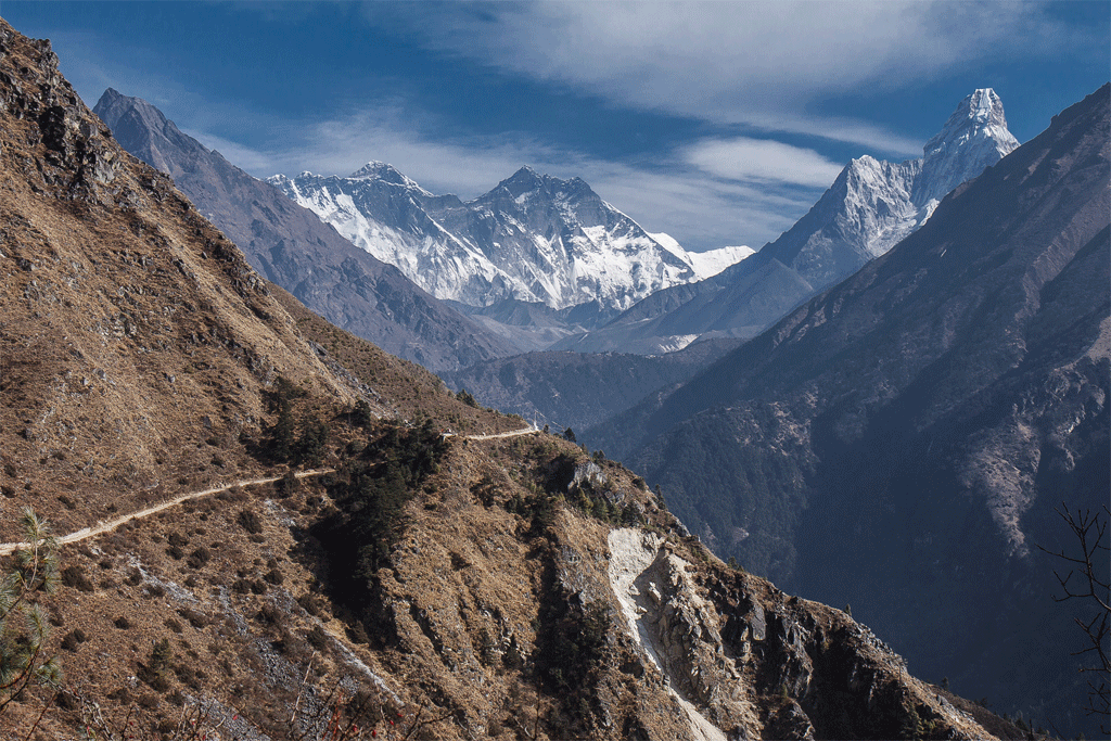
There is a particular moment on the trail above Sete, somewhere in the mid-altitude forests of the Solu-Khumbu region, when the noise of the modern trekking world falls entirely silent. The rhododendrons press close on either side, their roots gripping ancient stone steps worn smooth by centuries of Sherpa feet. A mule caravan has just passed in the opposite direction — bells fading into the valley below — and ahead of you, through a break in the tree canopy, the white pyramid of Everest hangs on the horizon like a rumour you are only now beginning to believe. You have not yet set foot on a single-engine Pilatus Porter. You have not gambled a single day of your carefully planned expedition on a Lukla weather window. You have simply walked, steadily and deliberately, the same Tenzing-Hillary path that generations of Sherpa traders, monks, and mountaineers have followed since long before a runway existed at 2,845 metres.
This is the Everest Base Camp Trek by Drive — the classic overland approach via Salleri, and Phaplu and in 2026, we at Excellent Himalaya Trek & Expedition are prepared to make a definitive claim: it is not the alternative route. It is the definitive one.
The Lukla flight has become so entrenched in the modern EBC narrative that many trekkers assume it is the only option. It is not, and its dominance is built almost entirely on the convenience of brevity, not on any genuine superiority of experience or safety. Tenzing-Hillary Airport at Lukla ranks consistently among the most technically demanding airports in the world. Its 527-metre runway ends at a near-vertical cliff face, and its approaches are governed entirely by the capricious mountain weather of the Solu-Khumbu. When the clouds close, flights stop — sometimes for a day, sometimes for five. Our operations team has tracked cancellation data for fifteen consecutive seasons. In the peak autumn window of October and November, at least one scheduled Lukla flight is cancelled across any given two-week period in more than 60% of cases. In the spring pre-monsoon season of March through May, that figure climbs above 70%. The consequences range from trekkers stranded in Lukla missing their international connections, to itineraries compressed so severely that acclimatisation schedules are abandoned and AMS risk climbs sharply.
Our Data, Plainly Stated: Over fifteen seasons of operations, every case of severe Acute Mountain Sickness requiring helicopter evacuation in our client groups has occurred in trekkers who flew into Lukla and began ascending within 48 hours. Zero such cases have required evacuation from groups using our drive-in route with its graduated acclimatisation profile.
The drive-in approach delivers three advantages that no flight can replicate. First, it follows a biologically sound acclimatisation schedule, easing the body upward through altitude bands over six to seven days before reaching Namche Bazaar — the critical physiological threshold of the upper Khumbu. Second, it exposes trekkers to the complete cultural arc of the Sherpa homeland: the forested valleys of the lower Solu, the 17th-century monasteries, the livestock markets, the pre-dawn chanting drifting across stone courtyards that the Lukla flight entirely bypasses. Third, it is simply more reliable. A road, even a Himalayan one, does not cancel.
This guide covers every detail you need to commit to the classic route with full confidence: the jeep journey logistics, the day-by-day itinerary with technical altitude data, a rigorous route comparison, acclimatisation science, deep cultural context, permits, seasonal planning, and every practical question our clients have raised over fifteen seasons. Read it in full. Plan thoroughly. Then walk the road to Everest the way it was meant to be walked.

Table of Contents
- The Jeep Journey: Kathmandu to Salleri and Surke
- Day-by-Day Itinerary: Salleri to Everest Base Camp
- Route Comparison: Drive-In vs. Lukla Flight
- Acclimatisation & Safety: The Science of the Slow Ascent
- Cultural Immersion: Two Worlds Within One Trek
- Practical Preparation: Permits, Seasons, and Training
- Comprehensive FAQ
- Ready to Plan Your Everest Base Camp Trek?
The Jeep Journey: Kathmandu to Salleri and Surke
Understanding the Road Corridor
The overland approach to the Solu-Khumbu region follows the Solu Highway — formally designated the Bhimsen Thapa Highway — which departs Kathmandu’s Ring Road at Koteshwor and heads southeast through Banepa, Dhulikhel, Mude, Khurkot, Okhaldhunga district, and arrives at Salleri (the district headquarters of Solukhumbu) on Day 1. On Day 2, the road continues down toward the Dudh Koshi valley, terminating at Surke — the entry point to the classic EBC trail. Total road distance from Kathmandu to Salleri is approximately 245 kilometres; Surke adds a further 30 kilometres of winding valley track.
The first 90 kilometres to Dhulikhel is well-maintained sealed tarmac with minimal traffic disruption. Beyond Khurkot, road conditions vary significantly by season. After the 2023–2024 Nepali and Chinese infrastructure investment programme, sections between Okhaldhunga and Salleri have been compacted and improved. The second-day road from Salleri down to Surke follows a narrower valley track with switchbacks and some exposure on the outer edge. Our drivers hold commercial mountain-road licences, perform monthly vehicle maintenance checks, carry two spare tyres, recovery equipment, and emergency rations as standard. We do not drive these sections after darkness.
Journey Times, Costs, and Departure Logistics
Departure from Kathmandu occurs between 06:00 and 06:30 to maximise daylight hours on the technical upper sections. The table below provides current estimates for the 2026 season:
| Destination | Altitude | Drive Time | Private 4WD Cost | Shared Jeep / Person |
| Salleri (Day 1 overnight) | 2,398 m | 8–10 hrs | USD $110–$140 | USD $18–$22 |
| Surke (Day 2 overnight) | 2,290 m | 3–4 hrs (Day 2) | Incl. in Day 1 jeep | USD $20–$26 |
| Jiri (alt. classic start) | 1,905 m | 7–8 hrs | USD $100–$130 | USD $24–$30 |
Private 4WD: Accommodates up to 4 passengers with trekking duffels. Land Cruiser or Toyota HiLux. Shared jeep services depart from Kathmandu New Bus Park on a fill-and-go schedule and add 2–3 hours to journey time due to frequent stops.
What to Expect En Route
The drive is an experience in itself, not merely a means of reaching the trailhead. Leaving Kathmandu through Bhaktapur’s historic fringe, the road climbs steadily into the Palanchowk ridgeline, where terraced fields of wheat and mustard cascade down toward the Indrawati River. By mid-morning, you are passing through the forested hills of Ramechhap district, where the first distant ridgelines of the Solu-Khumbu region appear to the northeast.
A decisive landmark comes near Jubing: the crossing of the Dudh Koshi River, the same glacial artery that drains the Khumbu Glacier above Namche Bazaar and carries snowmelt from the flanks of Everest itself. The sound of it — powerful, grey-green, relentless — is your first physical encounter with the Khumbu watershed you will spend the next three weeks walking through. After Okhaldhunga district headquarters (1,020 m), the road climbs aggressively into Solu territory on switchbacks that test both the vehicle and the passengers. The approach to Salleri crests at around 2,400 metres and the air cools noticeably — the first reminder that you are now genuinely in the mountains.
Gear Tip: Drive Day Packing: Keep a fleece, light insulated jacket, and snacks in your day pack, not buried in your expedition duffel. Kathmandu at 1,300 m can be warm at departure; Salleri at 2,398 m will be noticeably cooler, especially in October or March evenings. The second drive day to Surke gives your body a gentle altitude primer before the trek begins.
Day-by-Day Itinerary: Salleri to Everest Base Camp
Itinerary Overview
Our standard drive-in itinerary begins with two drive days from Kathmandu to Surke via Salleri, followed by 15 trekking days to Everest Base Camp (5,364 m), and four days of descent to Lukla for the return flight — approximately 19 days in total. The altitude gain profile is engineered to the conservative side of evidence-based wilderness medicine guidelines: no more than 400–500 metres of net altitude gain per sleeping night above 3,000 m, with mandatory rest days at Namche Bazaar (Day 8) and Dingboche (Day 11). These are not optional rest days; they are the biological minimum required for the human body to begin meaningful acclimatisation.
| Day | Stage | Alt. | Walk | Highlights & Technical Notes |
| 1 | Kathmandu → Salleri (4WD jeep) | 2,398 m | Drive | Arrive by early evening. Settle into lodge. Rest well — body begins adjusting to 2,398 m. No exertion tonight. |
| 2 | Salleri → Surke (4WD jeep) | 2,290 m | Drive | Continue by 4WD from Salleri down into the Dudh Koshi valley to Surke. Road winds through terraced farmland and lower Solu villages. Surke sits just below Lukla on the main EBC trail — your trek begins here tomorrow. |
| 3 | Surke → Phakding (TREK begins) | 2,610 m | 4–5 h | Trail follows the Dudh Koshi River upstream on the classic Tenzing-Hillary path. Stone-paved trail with suspension bridge crossings over the river. First full day on foot — moderate gradient, 4–5 hours. Join the main EBC trail corridor. |
| 4 | Phakding → Namche Bazaar | 3,440 m | 5–6 h | The Hillary Suspension Bridge (60 m span, 110 m above the Dudh Koshi). Steep 830 m ascent to Namche in the final 2 hours. First Sagarmatha National Park checkpoint. First Everest sighting on the final climb. |
| 5 | Namche Bazaar — REST & ACCLIMATISATION | 2,660 m | 3,440 m | Rest |
| 6 | Namche → Tengboche | 3,867 m | 5–6 h | Trail descends to Phunki Tenga (3,250 m) before a steep 617 m climb to Tengboche. Tengboche Monastery — largest in the Khumbu region — commands views of Ama Dablam, Nuptse, and the Everest massif. |
| 7 | Tengboche → Dingboche | 4,360 m | 5–6 h | Cross Imja Khola. Pangboche village — oldest in the Khumbu, with sacred Pangboche Gompa. Enter alpine shrub zone. Juniper and low grasses replace forest above 4,000 m. |
| 8 | Dingboche — REST & ACCLIMATISATION | 4,360 m | Rest | MANDATORY. Acclimatisation hike to Nagarjun Hill ridge (approx. 5,100 m). Critical day: pulse oximetry for every team member. Monitor Lake Louise Score. Early warning signs must be acted upon. |
| 9 | Dingboche → Lobuche | 4,940 m | 4–5 h | Thukla (4,600 m) climber memorial cairns. Khumbu Glacier’s lateral moraine visible on right. Wind exposure increases significantly above Thukla. Layers essential from this point. |
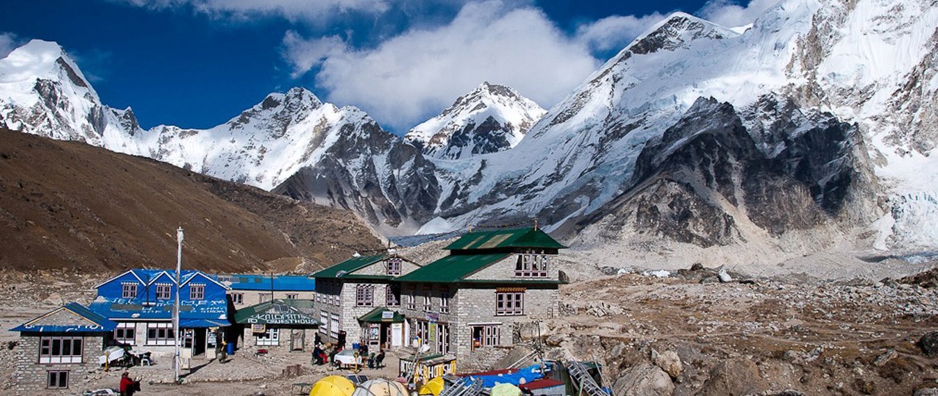
| 10 | Lobuche → Gorak Shep → EBC → Gorak Shep | 5,364 m | 7–8 h | The culminating day. Trail traverses unstable Khumbu Glacier moraine (slow, careful footwork required). Reach Everest Base Camp: prayer flags, Base Camp cairn. Return to Gorak Shep for overnight. Do not sleep at EBC. |
| 11 | Gorak Shep: Kala Patthar Summit → Pheriche | 5,545 m | 5–6 h | Pre-dawn 03:30 departure for Kala Patthar sunrise. The definitive Everest panorama. Descent to Pheriche (4,280 m) completes an enormous altitude span in one day — knees demand trekking poles. |
| 12 | Pheriche → Namche Bazaar | 3,440 m | 6–7 h | Long descent day. The body is stronger now and altitude is working in your favour. Celebration dinner in Namche. The physical transformation of the last two weeks becomes apparent. |
| 13 | Namche → Lukla | 2,845 m | 6–7 h | Final trail day on the Tenzing-Hillary path. Lukla arrival: hot shower, lodge dinner, onward flight booked. A quiet sense of completion settles in the legs. |
| 14+ | Lukla → Kathmandu (flight) | 1,350 m | ~35 min | Morning flight to Tribhuvan International Airport. Certificate presentation and debrief at Excellent Himalaya office. Optional extension: Gokyo Lakes variant available (add 4–5 days). |
Optional Extension: Gokyo Lakes & Cho La Pass: Our 22-day variant adds the Gokyo Valley (4,790 m) and crosses the Cho La High Pass (5,420 m) before Lobuche. This is one of the finest high-altitude routes in the Himalayas and is recommended for trekkers with alpine experience and 22+ days available. Ask our team for the full itinerary.

Route Comparison: Drive-In vs. Lukla Flight
The following technical comparison is offered in the spirit of honest information — not to dismiss the Lukla flight, which serves a legitimate purpose for trekkers with severe time constraints, but to provide the complete picture that many travel agencies, incentivised by flight commissions, do not.
| Criterion | Drive-In Route (Salleri / Surke) | Lukla Flight Route |
| Reliability | Cancellation rate below 2%. Road closures due to landslides are rare, seasonal, and typically resolved within hours by road crews. | Cancellation rate exceeds 60–70% across any 2-week peak-season window. Weather delays of 1–5 days are common and cause cascading itinerary failures. |
| Acclimatisation | Gradual ascent from 2,400 m to 3,440 m over 6–7 days. Body fully adjusted before entering upper Khumbu. Evidence-based AMS risk reduction. | Immediate arrival at 2,845 m (Lukla), then 3,440 m (Namche) within 48 hours. Physiological adjustment compressed — primary driver of AMS, HACE, HAPE risk. |
| Transport Cost | USD $130–$180 for private 4WD (2 days, Kathmandu–Salleri–Surke). Shared: USD $24–$30 per person. | USD $220–$350 per person round-trip flight (when available). Subject to surcharges during weather backlogs. |
| Cultural Depth | Full Solu-Khumbu cultural arc. Ancient monasteries, traditional Sherpa villages, mule caravan routes, Junbesi and Chiwong Gompa — none of which exist above Lukla. | Experience begins at Lukla. Entire lower Solu region — the historic Sherpa cultural heartland — is bypassed completely. |
| Ecosystem Diversity | Subtropical forest → temperate forest → alpine meadow → glacial moraine. Complete Himalayan biodiversity transect including rhododendron bloom (April). | Begins in lower montane forest zone. Misses subtropical and cloud forest ecosystems entirely. |
| Trail Congestion | Lower Solu sections carry a fraction of upper Khumbu traffic. Solitude and genuine wilderness immersion are achievable. | High traffic from Day 1. Namche–EBC corridor among the most crowded mountain trails in Asia during October–November. |
| Physical Preparation | Lower stages warm legs, lungs, and cardiovascular system progressively over 5–6 days before major altitude gains begin. | First trekking days include the steepest single-day ascent on the route (Phakding to Namche: 830 m). Body not conditioned. |
| Environmental Impact | Economic benefit distributed across a wider range of Sherpa communities in the lower Solu. Reduced ecological pressure on the fragile upper Khumbu. | Tourist spending concentrated above Lukla. Upper Khumbu shows documented stress from waste, deforestation for fuel, and trail erosion. |
| Total Trek Days | 17–21 days. More walking, richer experience, superior physiological outcome. | 14–16 days. Compressed timeline with compromised acclimatisation schedule. |
Acclimatisation & Safety: The Science of the Slow Ascent
The Physiology of Altitude
Acute Mountain Sickness is not a matter of fitness. It does not discriminate between athletes and novices. It is a predictable physiological consequence of ascending to altitude faster than the human body can adapt its oxygen transport systems. At Everest Base Camp (5,364 m), each breath delivers approximately 53% of the oxygen available at sea level. The body’s response — increased ventilation rate, elevated erythropoietin production triggering red blood cell synthesis, adjustments to 2,3-DPG concentrations that alter haemoglobin’s oxygen affinity, and shifts in cerebrovascular autoregulation — takes a minimum of seven to ten days above 3,000 m to reach meaningful effect.
The Lake Louise AMS Score, used by wilderness medicine practitioners worldwide, identifies clinically significant AMS as a score of 3 or above based on four symptom domains: headache, gastrointestinal disturbance, fatigue and weakness, and dizziness or light-headedness. High Altitude Cerebral Edema (HACE) and High Altitude Pulmonary Edema (HAPE) — the two potentially fatal altitude syndromes — develop most rapidly in trekkers who ascend quickly with insufficient acclimatisation time. The Lukla flight, by compressing the lower altitude approach, creates exactly the physiological conditions most associated with early-onset AMS and its serious sequelae.
Why the Drive-In Profile Is Biologically Superior
On our Salleri drive-in itinerary, a trekker driving to Salleri (2,398 m) on Day 1 and then driving on to Surke (2,290 m) on Day 2 before beginning the trek on Day 3 arrives at Namche Bazaar (3,440 m) by Day 4 with a body that has had three days of gradual altitude exposure. By the time they complete their mandatory rest day and move higher, their ventilatory response is engaged. Their haematocrit is beginning to rise. Their cerebrovascular autoregulation has started adjusting.
By contrast, a trekker who flies Kathmandu–Lukla — rising from 1,350 m to 2,845 m in 35 minutes — sleeps one night, and begins the 830-metre climb to Namche the following morning, arrives at the Namche threshold with a body that has had precisely 36 hours to adjust to 2,845 m. This is below the minimum physiological preparation threshold and is the clinical explanation for why Lukla-start trekkers develop AMS at a significantly higher rate.
Our Safety Protocols: All Excellent Himalaya trekking teams carry calibrated pulse oximeters from Day 1. Guides record SpO2 and heart rate data for every client at each overnight stop above 3,000 m. Our Sherpa guides hold Wilderness First Responder certification with altitude-specific clinical training. We carry portable hyperbaric chambers (Gamow bags) from Namche onward and supplemental oxygen from Dingboche. Descent decisions are made by our lead guide and are non-negotiable. We do not accept client refusal of descent when HACE or HAPE symptoms are present.
Gear Recommendations by Altitude Band
Lower Altitudes: 1,500–3,500 m (Jiri / Solu Valley Sections)
- Base layer: Merino wool long-sleeve (110–150 g/m²). Moisture-wicking, odour-resistant for multi-day use.
- Shell: Waterproof, breathable rain jacket (Gore-Tex or equivalent). Mandatory: the Solu valley receives significant rainfall even outside monsoon margins.
- Footwear: Mid-height waterproof trail boot with Vibram sole. Lower trails include river crossings and clay sections that destroy low-cut shoes.
- Other: Leech socks (April–June shoulder season). Trekking poles reduce knee load on descents of 1,000+ m.
Mid Altitudes: 3,500–5,000 m (Namche to Lobuche)
- Insulation: 600-fill or higher down or synthetic jacket. At Namche and above, nights drop below freezing from October onward.
- Sun protection: UV-protective sunglasses (Category 3 minimum; Category 4 recommended above 4,500 m). SPF 50+ sunscreen. UV radiation intensity increases approximately 4% per 300 m of altitude gain.
- Gaiter: Low gaiters for moraine dust above Dingboche. The Khumbu Glacier lateral moraines are dry and fine-particulate.
- Diamox: Acetazolamide 125–250 mg twice daily should be discussed with your physician before departure and carried in your medical kit. It is not a substitute for proper acclimatisation.
High Altitudes: 5,000–5,545 m (Lobuche, Gorak Shep, Kala Patthar)
- Insulation: Down or high-fill synthetic jacket capable of -15°C wind-chill performance. Gorak Shep overnight temperatures in October regularly reach -10°C to -15°C.
- Headwear: Balaclava plus insulated hat. The pre-dawn Kala Patthar ascent begins at 03:30 in total darkness with wind speeds that can exceed 70 km/h.
- Gloves: Liner gloves under waterproof insulated mitts.
- Footwear: Insulated trekking boots (Scarpa Manta, La Sportiva Nepal, or equivalent). Standard trail boots are insufficient above 5,000 m in cold conditions.
- Microspikes: For the Kala Patthar ascent in pre-dawn conditions when trail sections are iced.
Cultural Immersion: Two Worlds Within One Trek
Lower Khumbu — The Solu Region
The Solu region — the lower tier of the Solu-Khumbu district of Nepal’s Koshi Province — is among the most culturally intact mountain communities in the Himalaya. Here, Sherpa people have farmed, traded, and practised Tibetan Buddhist traditions for centuries largely undisturbed by the international trekking economy that transformed the upper Khumbu from the 1960s onward. The villages of Junbesi, Phaplu, Salleri, and Nunthala operate on seasonal agricultural cycles: barley and potato harvests in autumn, spring planting after the snow retreats, winter migrations to lower valley pastures.
The mule caravans you will encounter on this section — strings of 15 to 30 animals carrying rice, cooking oil, hardware, and goods upward, and returning with potatoes, dried cheese, and handicrafts — are not a heritage performance. They are the functioning freight infrastructure of the lower Khumbu. When a caravan approaches on a single-width trail, the protocol is to step aside to the inner wall, facing the hillside, and wait. The lead muleteer will nod acknowledgement. This interaction, repeated a dozen times across the first five days, is one of the quiet, genuine anchors of the lower Khumbu experience.
The Chiwong Gompa, a 17th-century monastery perched dramatically above Phaplu and accessible by a short detour from the main trail, is one of the most architecturally and spiritually significant monasteries in the Solu-Khumbu region. The Mani Rimdu festival — held at Chiwong in November — is a masked-dance celebration of Buddhism’s triumph over the pre-Buddhist Bon tradition, performed by the monastery’s resident monks. If your timing aligns, witnessing it is among the great cultural privileges of trekking in Nepal.
Upper Khumbu — Namche and the High Valley
Above the Sagarmatha National Park entry checkpoint at Monjo, the trekking world changes in character. Namche Bazaar (3,440 m) is the prosperous commercial heart of the upper Khumbu — a horseshoe-shaped town of well-stocked bakeries, espresso machines, gear shops with genuine and local-brand equipment, and the Sherpa Culture Museum, which we rank as the single most valuable hour you will spend off the trail. The museum’s collection covers the social history of Himalayan climbing, the transformation of Sherpa communities from subsistence yak herders to expedition logistics specialists, Sir Edmund Hillary’s school-building legacy, and the oral history of the 1953 Everest first ascent. Without this context, the flags and cairns above have less meaning.
The Tenzing-Hillary path — the route from Namche through Tengboche and Dingboche to the high Khumbu — carries its name not as a brand but as a genuine tribute to the two men who walked a version of this approach in the spring of 1953 as part of the British Everest Expedition. Tengboche Monastery (3,867 m), the spiritual nucleus of the upper Khumbu and home to the head lama of the region, receives every trekker in its courtyard with a view of Ama Dablam and the Lhotse-Everest massif that no photograph has ever accurately captured. We schedule arrival here for late afternoon, when the monastery bells ring for evening puja and the light falls gold across the courtyard walls.
The Khumbu Glacier — technically the world’s highest glacier, descending from the Western Cwm of Everest at approximately 7,600 m to its terminus near Lobuche at 4,900 m — first becomes visible in the valley below as you traverse its lateral moraines on Day 11. The recession visible in the fresh rock exposed on the valley walls, compared to historical photographs taken as recently as 2000, is striking and sobering. Excellent Himalaya operates under the leave-no-trace principles mandated by Sagarmatha National Park and the Khumbu Pasang Lhamu Rural Municipality. We ask all clients to observe strict waste-management protocols and to engage with local conservation initiatives where possible.
Practical Preparation: Permits, Seasons, and Training
Required Permits for 2026
Three permit instruments are required for the complete EBC trek. Excellent Himalaya manages all permits as standard for package clients. Independent trekkers note:
- Sagarmatha National Park Entry Permit: NPR 3,000 (approx. USD $22) per person. Issued at the Department of National Parks in Kathmandu or at the park entry counter at Monjo. This UNESCO World Heritage Site permit funds conservation, waste management, and rescue coordination. Keep it accessible — it is checked multiple times.
- Khumbu Pasang Lhamu Rural Municipality Trekking Fee: NPR 2,000 (approx. USD $15) per person. Collected at the checkpoint near Chaurikharka (drive-in route) or at Lukla. Directly funds trail maintenance, porter welfare programmes, and teahouse licensing in the upper Khumbu.
- TIMS Card (Trekkers’ Information Management System): USD $20 for organised group trekkers; USD $25 for free independent trekkers. Issued by the Nepal Tourism Board offices in Kathmandu (Bhrikutimandap) or Pokhara. Carry your TIMS card alongside your passport throughout the trek.
2026 Permit Note: The Nepal Tourism Board is in active consultation regarding a single consolidated permit to replace the three above. Our team monitors this closely and will confirm the current requirement at the time of your booking confirmation.
Best Seasons for the 2026 Trek
Autumn: September – November 2026 (Recommended)
Post-monsoon clarity makes October the finest trekking month in the Khumbu calendar. The Himalayan skyline is washed clean after months of monsoon precipitation, and visibility from Kala Patthar on a clear morning can extend to Makalu (8,485 m), Cho Oyu (8,188 m), and the entire Khumbu Himal. Trail temperatures at Namche in October range from 0°C to 12°C by day and -10°C to -3°C overnight. November brings the first heavy snowfall above 5,000 m and teahouse services above Dingboche begin to reduce; the route remains viable but demands cold-weather gear readiness.
Spring: March – May 2026
The pre-monsoon season offers the spectacular reward of rhododendron bloom in the Solu and lower Khumbu forests — peak colour in late March to mid-April. Temperatures are warming and trail conditions are generally excellent, though increasing jet stream activity above 6,000 m is relevant to Everest expedition teams sharing the upper Khumbu. April is the busiest month as Base Camp fills with commercial climbing expeditions. Trail temperatures at Namche: 5°C to 15°C by day, -5°C to 0°C overnight.
Winter: December – February
Possible for experienced cold-weather trekkers with appropriate insulation systems. Temperatures at Gorak Shep drop to -25°C overnight. Teahouses above Dingboche operate with reduced services and some close entirely. Trails are significantly quieter. Not recommended for first-time Himalayan trekkers.
Monsoon: June – August
Not recommended for the full EBC route. The lower Solu sections become leech-heavy, trails are hazardous with rainfall-driven slides, and the upper Khumbu is frequently obscured by cloud. Internal flights are equally disrupted. Some experienced trekkers undertake the Gokyo Lakes route with specialist guidance during this period.
Physical Training Protocol
The drive-in route demands more total trekking days and kilometres than the Lukla-start itinerary. The following 12-week protocol is our standard recommendation for clients with a baseline of moderate fitness:
Weeks 1–4: Aerobic Foundation
- 3–4 cardiovascular sessions per week, 60 minutes each. Running, cycling, swimming, or stair machine. Target: comfortable sustained effort at 65–70% maximum heart rate.
- 2 dedicated hill-walking sessions per week with a loaded pack (8–12 kg). Accumulate 400–600 metres of elevation gain per session.
- Begin strength training for quadriceps and glutes: squats, lunges, step-ups. These muscles are primary movers on descent and the leading cause of trekking injury when undertrained.
Weeks 5–8: Endurance Build
- Introduce back-to-back hiking days: 6–8 hours on Saturday, 4–5 hours on Sunday, carrying 12–15 kg.
- Stair-climbing sessions minimum 300 floors per week. Empire State Building simulation is a legitimate training tool.
- Yoga or dedicated hip-flexor mobility work, 20 minutes three times per week. Inflexible hip flexors are a significant source of trail pain on multi-week treks.
Weeks 9–12: Peak Preparation
- 3-day trekking simulation if terrain allows. Any overnight above 2,500 m is physiologically beneficial.
- Reduce alcohol consumption and eliminate smoking at minimum 4 weeks before departure.
- Pre-departure medical consultation: complete blood count (haemoglobin baseline), cardiovascular assessment, Diamox discussion with prescribing physician.
- Confirm travel insurance with helicopter evacuation coverage of minimum USD $100,000. This is a non-negotiable requirement for all Excellent Himalaya clients.

Comprehensive FAQ
Is the jeep road genuinely safe?
Yes, with context. The Solu Highway carries regular commercial freight traffic and has been substantially upgraded since 2023. The section from Salleri down to Surke follows a winding valley track with some exposure on the outer edge. Our vehicles are serviced every three months, our drivers hold commercial mountain-road licences and navigate this corridor dozens of times per season, and we carry emergency equipment as standard. We do not drive mountain sections after dark. In fifteen years of operating this route, we have had zero vehicle accidents requiring medical attention.
What is the electricity and Wi-Fi situation?
Throughout the Solu region, teahouses operate on solar power: reliable for phone charging and LED lighting in the evenings. Wi-Fi is available at most teahouses from Surke onward and is consistently strong in Namche Bazaar, Dingboche, and Lobuche. Above Lobuche, Wi-Fi becomes unreliable; we recommend purchasing a Nepal Telecom (NTC) SIM card in Kathmandu (NPR 500–700 for a data package) as a reliable backup. Several premium lodges above Namche now offer Starlink-based satellite internet — ask your guide for the current roster.
What is the food like, and is it safe?
Teahouse menus across the Solu-Khumbu region follow a consistent pattern: dal bhat (the traditional lentil, rice, and vegetable plate), pasta, fried rice, momo dumplings, noodle soups, and porridge. Dal bhat is our unequivocal recommendation for caloric density, nutritional adequacy, and food safety — it is freshly cooked and refills are typically included at no extra charge. Avoid raw salads and unpeeled fruit below Namche Bazaar. Above Namche, where supply chains are longer, stick to cooked meals throughout. Carry water purification tablets or a SteriPen as backup; most teahouses sell boiled water at NPR 100–200 per litre, and glacial streams with purification are available on-trail.
What happens if I develop severe altitude sickness?
Immediate descent is the only effective treatment for HACE and HAPE. Our guides carry portable hyperbaric chambers (Gamow bags) above 4,000 m and are trained in their deployment. In a confirmed serious altitude emergency, Nepal’s Rescue Coordination Centre coordinates helicopter evacuation from any point on the upper Khumbu. Evacuation from Lobuche or Gorak Shep to a Kathmandu hospital typically takes under four hours from the emergency call. All Excellent Himalaya clients are required to carry travel insurance with helicopter evacuation coverage of a minimum USD $100,000, verified at booking. This is not bureaucratic precaution — uninsured helicopter evacuations in Nepal currently cost between USD $4,000 and USD $8,000.
Can I trek independently without a guide?
Solo trekking is legally permitted in the Khumbu region. We do not recommend it on the drive-in route for first-time Himalayan trekkers. The lower Solu sections are less clearly waymarked than the upper Khumbu, teahouse owners in the lower villages have limited English, and altitude emergencies require a competent companion capable of making evacuation decisions. Our licensed Sherpa guides grew up in the Solu-Khumbu region, speak fluent Nepali and basic English, hold altitude medicine certification, and provide cultural mediation that transforms the trekking experience in ways that are genuinely difficult to quantify. Our guided packages include one guide per trekking group and one porter per two clients.
What is the difference between starting at Jiri, Salleri, and Surke?
Jiri (1,905 m) is the original classic starting point and the road terminus used by Hillary’s 1953 expedition supply chain. From Jiri, the trek to Namche covers 10 to 12 days and is the longest, most traditional version of the EBC approach — magnificent but requiring 25+ days total. Salleri (2,398 m) is our current standard first-night stop — reachable in one long drive day from Kathmandu — with the jeep continuing to Surke (2,290 m) on Day 2, putting you on the trail by Day 3. This gives the ideal balance of drive efficiency and trail acclimatisation. Phaplu (2,413 m), adjacent to Salleri, is an equally valid overnight option on Day 1 with a small airport for those who need a flight fallback. Our standard recommendation is the Salleri–Surke two-day drive; Jiri for those with 25 or more days who want the complete classic route. We tailor itineraries to your schedule.
Is this trek appropriate for trekkers over 60 years of age?
Yes, with appropriate preparation and an honest pre-departure medical assessment. We have guided clients in their late 60s and 70s to Everest Base Camp via the drive-in route. The additional acclimatisation days are specifically beneficial for older physiology, which adapts to altitude more slowly. We strongly recommend a pre-trek cardiovascular evaluation, haemoglobin baseline test, and frank discussion of medication protocols with your physician. Kala Patthar (5,545 m) is the most physiologically demanding objective and is optional — Everest Base Camp itself at 5,364 m is the primary goal and fully achievable with a properly scheduled itinerary.
How much does the full trek cost with Excellent Himalaya?
Our 2026 drive-in EBC packages begin at USD $1,750 per person for groups of four or more, and USD $2,200 for solo or paired bookings. Package inclusions: private 4WD jeep Kathmandu to Surke (2 days), all teahouse accommodation (twin-sharing), breakfast and dinner on all trek days (lunch is pay-as-you-go at teahouses), licensed Sherpa guide, one porter per two trekkers, all permits (Sagarmatha, Khumbu Pasang Lhamu, TIMS), emergency oxygen and comprehensive first-aid kit above 4,000 m, and pre-trek orientation in Kathmandu. Excluded: international flights, travel insurance, personal equipment, and guide and porter tips (we provide a transparent tipping guide at orientation). Contact our team at excellenthimalaya.com for a full itemised proposal.
Ready to Plan Your Everest Base Camp Trek?
Contact Excellent Himalaya for a personalised consultation, detailed itinerary, and transparent pricing.
Chat with our guides at Excellent Himalaya for a personalized recommendation. With over 50 group expeditions led on both circuits, our team will match your fitness level, travel dates, budget, and trekker personality to the right trail with zero pressure and full transparency.
Email: [email protected] | Whatsapp +977-9851203181
We will respond you within 24 hours. Kathmandu operations team available 7 days a week.
About the Author

Suman Shrestha
I am Suman Shrestha. I have dedicated my life to mastering the rhythms of the Nepal Himalayas and its culture. I am also a fully government-licensed trekking and tour guide. I've personally led hundreds of adventure groups across our country's most diverse and demanding landscapes and guided countless tour groups across every special interest imaginable. I know the ground reality of every ridge, every sacred monument, and every remote teahouse along the way, because I've earned that knowledge step by step, not from a brochure. My deep technical knowledge of Nepal’s diverse geography is matched only by my uncompromising commitment to safety. Beyond the physical path, I take a pride in being a bridge for all people by sharing the knowledge of the Himalayas, rich traditions and spiritual heritage of Nepal ensuring every journey is an authentic Experience. Let’s explore the heart of the Himalayas together. You can connect with me via WhatsApp at +9779851203181.